Our travels have taken a shift in another direction as we head towards our next adventure, spending extended time in Ohio helping Terry’s elderly parents. We know this next phase in our lives will come with some challenges but we believe the rewards will outweigh those ‘bumps in the road’ we may encounter. The biggest trial for two nomads will be sitting still for so long after traveling for the past ~2 years. We see organic gardening in our near future and hitting the road again later in the year to avoid the cold midwest winters.
Our new home will be on the parents’ property, where an RV pad is awaiting us. The emphasis here is on “new home” as that is what we now have and the reason we have spent so much time in Elkhart, IN, most likely the RV capital of the country. Yep, I have given up my dream for a larger motorhome for a slightly smaller, new RV, with the promise of more international travel, right honey? 😉
Love my new kitchen!
Living room w/ a cozy fire
One of the more important rooms
Our second story
The master suite
Terry has always liked the idea of a smaller RV (cause he’s the dude who has been drivin’ it) but I have shuddered at the thought of the two of us co-existing in such small quarters. Given that we are outside so often, it has not been a problem. Surprisingly, our new RV seems more spacious, is much more efficient, and has so many upgrades from our three-year old model. For someone who loves to cook like I do, more kitchen counter space is heavenly and a walk-in closet in an RV can truly be just that.
DRV manufacturing plant
Impressive frame
Tour guide Kyle giving a demonstration
Large slide being installed – notice the blue mood lighting in the ceiling
Isn’t she pretty?
Although we already owned a DRV Mobile Suites we decided to tour their manufacturing plant, which I must admit was fascinating. We felt more secure in our decision to trade in our 3-year old model for another MS after watching the construction from the ground up, everything done by hand. Another bonus was meeting two lovely couples who are planning to hit the road full-time soon. 🙂
If you liked this blog post, why notscroll up to ‘Follow Us’ and enter your email address? You just might find something that interests you.
As we looked west to the San Andres Mountain range rising from the desert floor, wave after wave of blinding white seemed to stretch as far as the eye could see, rolling out to the horizon. We had arrived at one of the world’s great natural wonders, White Sands National Monument.
Approximately 15 miles outside of the town of Alamogordo, New Mexico lies the world’s largest gypsum dune field, 275 square miles of white, glistening sand dunes, ever-shifting, ever-changing. Technically this should not be here, as gypsum is soluble in water, which makes it a very rare form of sand. Typically, rain and snow high in the mountains carry dissolved gypsum to rivers, which then flow to the sea. But the Tularosa Basin is not typical; no river drains this desert land so the gypsum that collects here becomes trapped, along with various other sediments.
Terry, blending in nicely with the white sand and azure sky
Me, playing barefoot in the cool sand.
During periods of rain or snow, water evaporates in the Tularosa Basin, breaking the gypsum down into a crystalline form known as selenite. Freezing, thawing, wetness and dryness break the crystals down even further into fine grains of sand. As the wind tosses them along the ground, theses tiny grains crash into one another, scratching their surface. These scratches change the way light reflects off the sand particles, causing them to appear white.
White Sands is a living laboratory, providing scientists an understanding into our past and a peek into our future, as they explore the gypsum dune field on Mars.
Bleached earless lizard – photo credit nps.gov
Tenacious tree anchored in the sands nearing sunset
Animal tracks in the shifting sands
Twisted weathered tree trunk
Soaptree yucca in the fading light
As we drove the 8-mile loop road through the monument, we had the feeling we would begin sliding at any moment, as it appeared we were driving on an icy, snow-packed road, with snowdrifts as far as the eye could see. I wondered what keeps dunes like this, so exposed to the wind and weather, from simply blowing away. New Mexico does have its fair share of high winds with so much open desert. I learned that the dunes can shift west to east up to 30 feet per year but it is ground water, found 12-36″ below the surface that keeps the dunes at 100% humidity year-round, helping to stabilize these massive sand piles.
Looking out over this vast expanse of white, you would think that nothing could live here, but many species of plants and animals do just that, having adapted and evolved over time to a white pallor that provides the perfect camouflage. The bleached earless lizard is one who is coping well to a life without color.
Terry, looking out over the Sacramento Mountains, at sunset
Many come here to slide down the massive dunes, purchasing wax-coated sleds in the visitor center’s gift shop. I decided to let the kid in me run barefoot up and down the dunes, while Terry, who had cut his toe earlier in the day, kept shoes one, shaking his head as he watched me run up one dune and down another.
As the sun began to dip below the San Andres Mountains, we sat watching in awe, as this wonder of nature was wrapped in a golden glow.
Sunset over the San Andres Mountains
If you liked this blog post, why notscroll up to ‘Follow Us’ and enter your email address? You just might find something that interests you.
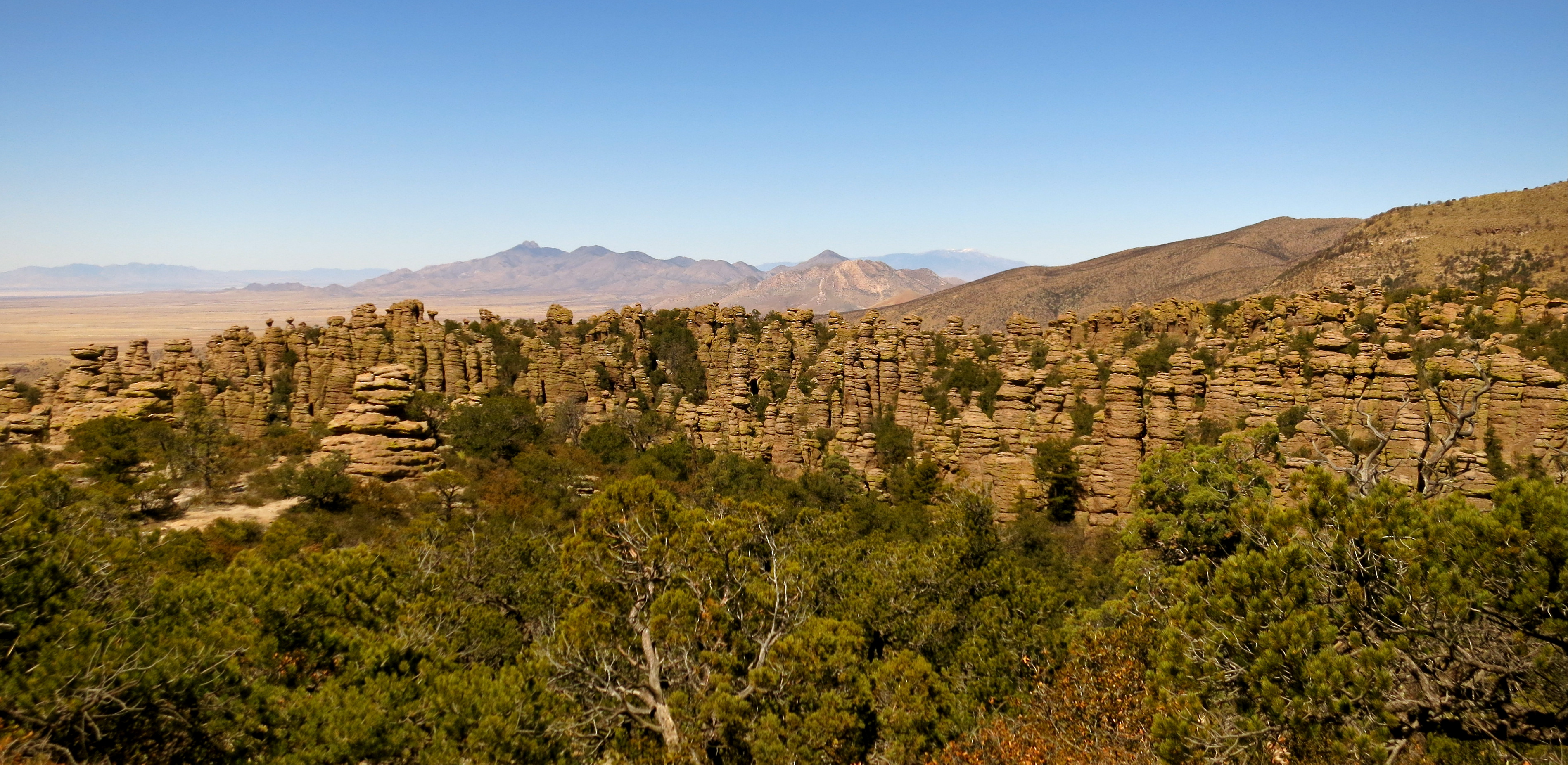
Chiricahua Mountains…ancient homeland of the Apache, sky island, “Land of Standing-up Rock”? The Chiracahuas are all this and so much more.
Chiracahua Mountain Range
As I walked among the towering hoodoos I marveled at the fact that we spent 25 years of our lives in Phoenix and Sedona and had never traveled to the Chiracahuas, being the hikers we are. Granted, it is not a short jaunt across town, just 50 miles north of the Mexico border, but the mountains are so breathtaking and the history of the area so rich, I’m not sure why we waited. Perhaps we just needed to be a little more seasoned to appreciate all that is here.
The Chiracahua Mountain range had its origins roughly 27 million years ago, when eruptions from the Turkey Creek volcano spewed ash over 1200 square miles. This sky island, which is essentially an isolated mountain range rising above a grassland sea, developed over many millenia into the rock pinnacles that we see today. They stand like guardians of the forest and send the clear message that you are now in Chiracaqua country.
A little perspective on these giants
Can I squeeze through that crack?
Not a good time for an earthquake!
The Chiracaqua Apache claim this land as their ancestral home, with evidence of their existence in these mountains dating back to the early 1400’s. They named this range the “Land of the Standing-Up Rock” and lived peacefully here until the Europeans stepped in to declare this land theirs. Led by Cochise and Geronimo, the Apache staunchly defended their ancestral homeland. The last of the Apache finally gave up the fight in 1886, surrendered, and were later relocated by the government to Oklahoma and New Mexico, never to return to this sacred land. So much more could be said here but I will just add that I felt a sadness as I walked the trails, reflecting upon all the Native Indians have so unjustly lost .
There is such an interesting blend of local and exotic plant and animal species here that it is said to be one of the most biodiverse regions in North America, boasting over 1200 species of plants alone. Plants and animals from four different ecosystems come together in this range. Birders flock here for the diversity as well, seeing many species of birds that can normally only be seen in Mexico. We visited for the hiking, to witness Mother Nature at her finest, rock formations precariously balanced in such a way that it appeared a strong wind could topple these giants.
Mushroom rock
Big Balanced Rock
Burned area near Inspiration Point
Terry in the grotto on the Echo Canyon trail
Chiracaqua National Monument was established in 1924 to preserve and protect these 12,000 acres and in 1934 the Civilian Conservation Corps began to tackle the job of roads and trails. Today there are ~20 miles of trails for your hiking pleasure and 86% of this sky island lives on as pristine wilderness.
To experience as much of the Chiracaquas as we could in one visit, we chose the Big Loop, a combining of many trails that resulted in a lovely 10-mile hike. There are a few ways you can tackle this trail and, based on a tip provided to us by a Park Ranger at Fort Bowie the day before, we elected to take the shuttle from the visitor center to the Echo Canyon Trailhead (arrive prior to 8:30 am). From there we followed this route: Echo Canyon Trail> Hailstone Trail > Mushroom Rock Trail > Big Balanced Rock Trail > Heart of Rocks Loop (where most of the named formations stand) > Sarah Deming Trail > Lower Rhyolite Canyon Trail. This and a little other meandering will get you a fabulous 10-mile hike, with the last three miles being downhill. 🙂
Heart of Rocks Loop:
Pinnacle Balanced Rock
Duck on a Rock
Kissing Rocks
Camel’s Head
Punch & Judy
Wandering among these geologic wonders that time and weather have painstakingly created, you just might feel the spirits of the ancient ancestors who walked this ground…truly a sacred experience.
If you liked this blog post, why notscroll up to ‘Follow Us’ and enter your email address? You just might find something that interests you.
After receiving an email recently from someone I follow, I felt compelled to dust off a post that I have had sitting around for some time and present you with a “blast from the past”, Dana Point in a different light.
I doubt you will see any travel advertisements portraying this beachside city in the gray light of a foggy day but sometimes our travel plans present us with one of Mother Nature’s less than sunny moods, and this day was one of those. I decided to go with the flow and for me there has always been something very soothing about being near the ocean when the fog has laid down a quieting blanket of white, muffling all but the pounding surf and squawking shorebirds.
Shorebirds gone wild!
Dana Point, sitting halfway between San Diego and Los Angeles, covers a total area of roughly 30 miles, 7 of those being land and 23 being water. All things revolving around water draw visitors to this beachside resort city: romantic walks on beautiful sandy beaches, tide pools teaming with all sorts of fascinating ocean creatures, deep-sea fishing adventures, some of the best surfing around, and a beautiful harbor housing two marinas, 2500 boats, and 30 boutique shops.
Silently a sailboat slips into the harbor
On the land side, 23 beautifully manicured parks dot the city, many with views of the ocean and a three-mile public trail system that link together all those contained within the headlands.
Ocean Institute
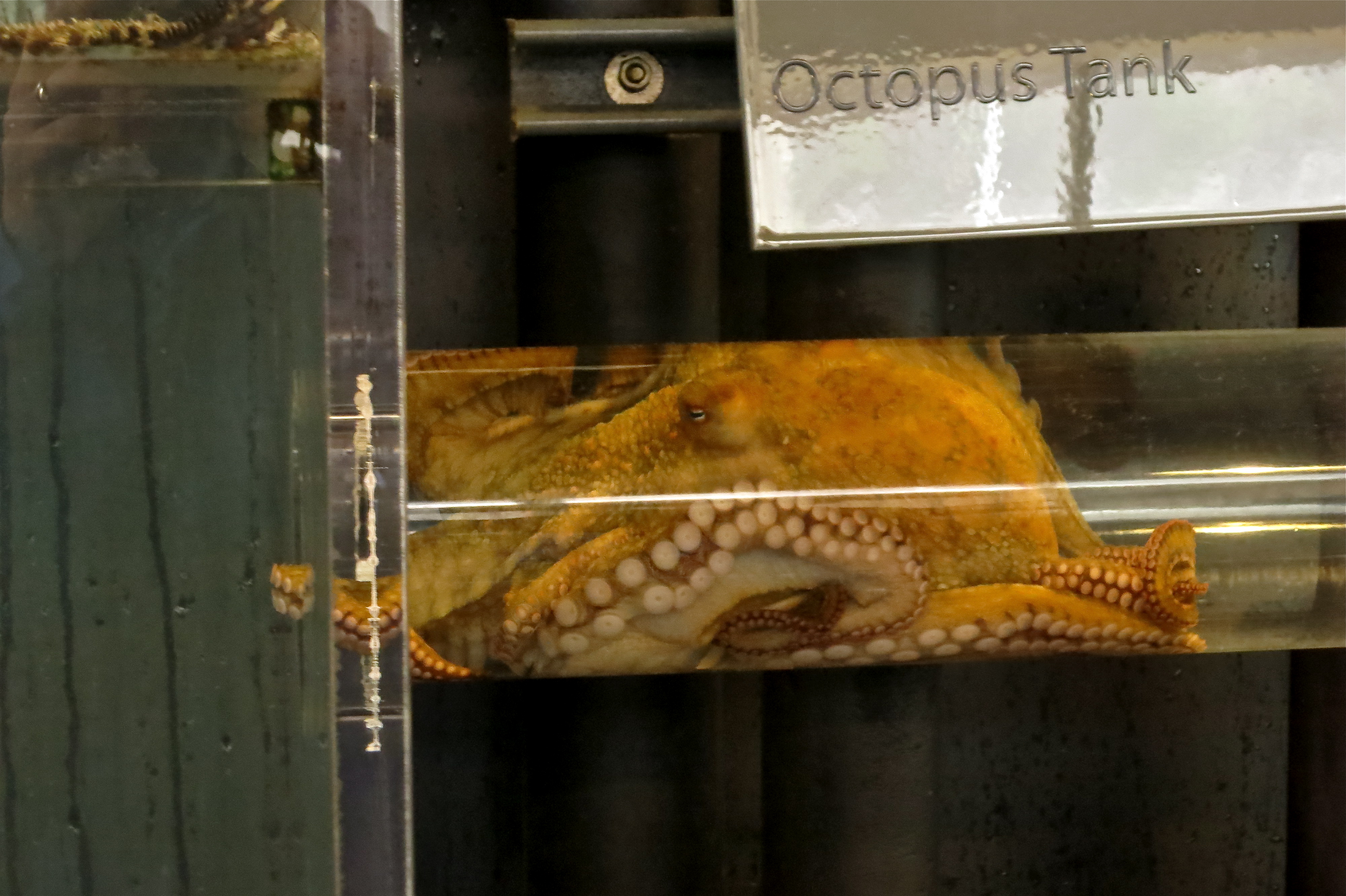
This city boasts the title of “Whale Capital of the West” because of the many types of whales that use this point as a navigational landmark for their migrations north and south. I decided to head to the Ocean Institute that sits in the harbor to see what I could learn.
The Ocean Institute, founded in 1977, is a non-profit dedicated to ocean awareness and preservation. It serves 135,000 students annually and is open to the public on the weekends. It is a blending of museum, small aquarium, and ocean classroom labs, with interactive stations and holding tanks of indigenous ocean species spread throughout its buildings.
An octopus, moving from one tank to another, awaiting feeding
You can watch the feeding of an octopus, dissect a squid, examine sea life under a microscope, or educate yourself on the life cycle of a jellyfish. Step outside and tour The Pilgrim, a replica of a hide brig, or hop on a charter boat for a whale-watching adventure.
The Pilgrim
While fixating on the jellyfish tanks I saw someone who looked vaguely familiar but, having his back to me, I wasn’t sure. Does this young man resemble someone you may know?
Mystery man
Click here to learn the identity of this mystery man. Did you guess correctly? Come on, be honest. 😉
Actually, this was a planned meeting and this young blogger has the same warm, playful spirit that shines through in his posts, not to mention the wicked good photographs he takes! One of the first posts of his that I read was one in which he took a road trip and brought along his mother, grandmother, and uncle. He reeled me in after that and I have followed him ever since (not stalking, mind you!). Lucky me to have the chance to spend a few hours with the infamous Rommel of The Sophomore Slump. 🙂
Little ray of sunshine on a rainy day
If you liked this blog post, why notscroll up to ‘Follow Us’ and enter your email address? You just might find something that interests you.
This is the way part-time resident, novelist and screenwriter (Legends of the Fall) Jim Harrison describes Patagonia. We just blew through this funky little town several years ago when we visited so we decided it was time to show her some respect.
Our good friends Stan and Marilyn were hunkered down here for a few days while a winter storm passed by and we wanted to see them one last time before they began their journey back home. Even though the weather wasn’t perfect, what better place to enjoy nature for a few hours than in a world-class birding hot spot. Even if you are not a birder, once here we are told, you may discover your inner passion for these colorful, feathery creatures who far outnumber people. This little gem has been named in the publication Fifty Places to Go Birding Before You Die: Birding Experts Share the World’s Greatest Destinations.
Bridge over Patagonia Lake
Nestled between the Santa Rita and Patagonia Mountains at a 4000-foot elevation, this town has a unique vibe, a quirkiness about it that suits its residents just fine. Preserving its history, its rich riparian area, and sustainability are some of Patagonia’s top priorities.
Just west of town lies the Patagonia-Sonoita Creek Preserve, “home to one of Arizona’s few permanently flowing streams, endangered fish, butterflies, and birds”. Adjacent to town the Nature Conservancy has also staked its claim and the organization Native Seeds/SEARCH maintains a farm for preserving and growing seeds of endangered crops that grow in this area. Scratch below the surface, dig a little deeper, and you will find some hidden gems in small town America. We will definitely be back.
Patagonia Lake
Although I have bemoaned the fact that I need a camera with better zoom ability to catch the beauty of these little feathered friends, we headed out to Patagonia Lake State Park & Sonoita Creek Natural Area with binoculars in hand (and camera just in case I got lucky). Our first stop was to the visitor center to ask where the most birds can be seen. Many agreed that if we stood in their side yard, where their feeders are, we would see a wide variety, but they also decided to share a couple of trails that might offer some enjoyment. We opted for the birding trail, sans tour guide, where we could get a little exercise and hopefully see some birds.
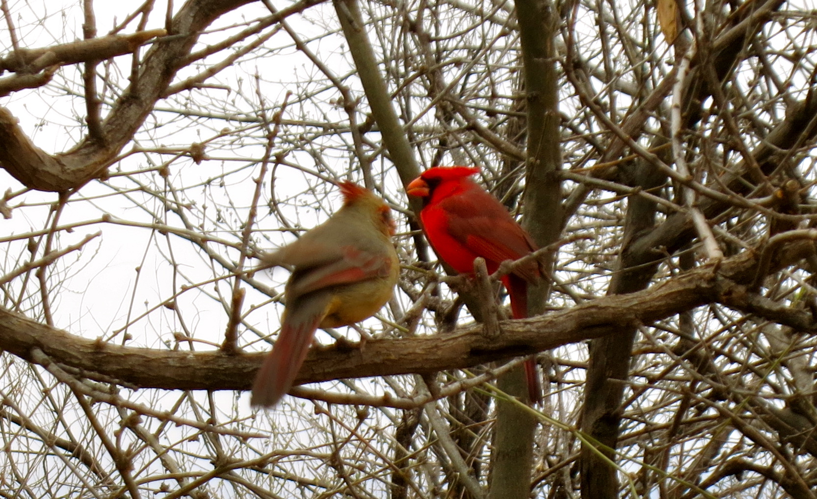
A pair of cardinals hiding in the thicket
For the record, I am not a birder, but I must admit to sending out a little prayer into the universe to have a chance meeting with the reclusive Elegant Trogon, the colorful, tropical bird that brings birders by the thousands to southeast Arizona each year. Patagonia and its surrounding mountain ranges are the farthest north this little beauty ventures so I wasn’t very optimistic about my chances.
Who are you lookin’ at?
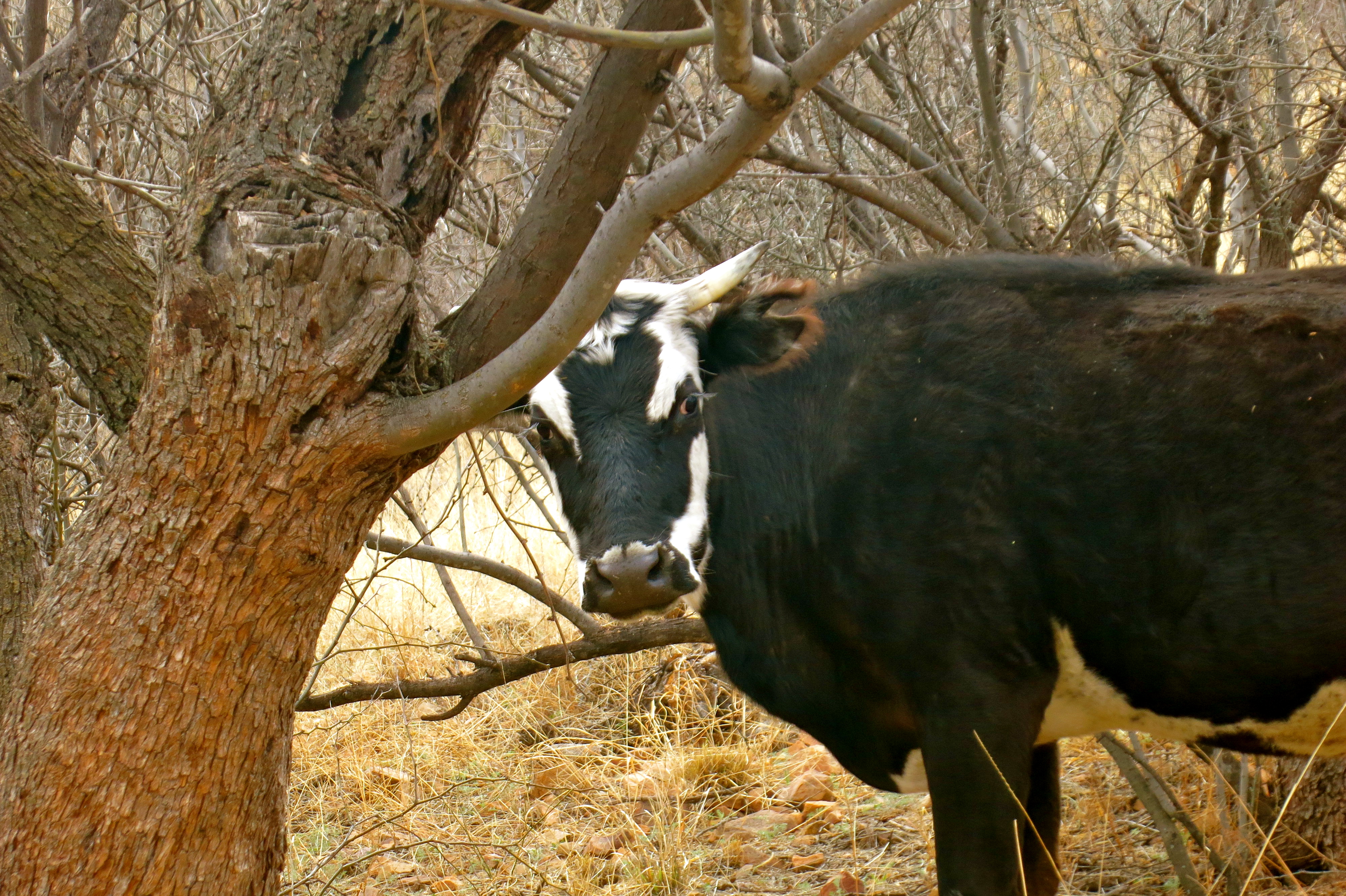
The first mile didn’t offer much to entice our sense of sight, other than some inquisitive cows, a burbling creek and the sound of many bird species that filled the air. We were relishing the fresh air after being cooped up inside waiting out the winter storm. Following the creek around a bend, our friend Marilyn whispered, “there he is”. The gods were smiling down on us as we watched this little beauty quietly perched on a branch. I kept snapping away in the hopes of having a few viable photos then traded off with Terry so I could see him in all his splendor up-close through the binoculars. Terry was able to creep even closer when the Elegant Trogon flew from his perch to the ground and back up again. Here is what he found to be much more interesting than us:
Elegant Trogon meets Mr. Lizard
Hammin’ it up for the camera!
The big question from everyone we met on the trail was “did you see it?”. We showed our photos many times before we got back to our vehicle. We were ready to take off when someone tapped on Stan’s window. Rolling it down, the group standing there asked to see the photos. Guess this colorful little fella is something of a rock star!
Velvet Elvis
Namesake on velvet
Lovely dining setting
Our time with Stan and Marilyn was coming to an end, and what better way to find solace than to nourish our bodies and toast this heart connection with a glass of nice French wine. We headed over to the Velvet Elvis Pizza Company, where the lovely Ecuadorian proprietor and executive chef, Cecilia, creates the most delectable dishes. Her pizzas are gourmet and the remaining menu has a Latin American flair. What a find in this funky little town and the perfect way to bid adieu to our friends, with the promise of a visit later this summer.
“Last supper” at the Velvet Elvis
For a great gallery of Arizona birds, check out the Lowe’s RV Adventures, and while you’re there, spent some time reading about their many wonderful travel exploits.
If you liked this blog post, why notscroll up to ‘Follow Us’ and enter your email address? You just might find something that interests you.