Red Rock Energized ~ Sedona, AZ

Sedona has long held the reputation as a world-wide spiritual mecca, drawing healers, artists, and spiritual guides.  Whether or not you believe in her vortex energy, there is no denying the breathtaking views that can be seen in every direction. Having lived in Sedona for many years, we believe the magnificent red rock formations and evergreen vegetation exudes energy, a year-round feeling of renewal and sense of peace, and is one of the reasons we come back year after year to hike her enchanting trails.

We recently found ourselves back in Sedona to visit friends, get a tune-up for me, and do a little hiking.  Dead Horse Ranch State Park in Cottonwood is where we tend to stay, a peaceful park that is just far enough away from the tourist pace of Sedona, yet close enough to hiking trails.  Finding a trail we haven’t already tackled is the biggest challenge, particularly Terry, who I think has pretty much hiked them all.  I did manage to introduce him to a newer trail that I hiked a few years ago with a girlfriend and he agreed to tag along with me on one that I had yet to cross off my list.

Here are two hikes we would highly recommend should you find yourself wandering around Sedona’s red rocks:

1)  Slim Shady / Highline / Baldwin / Templeton (with a twist)

Better known by many as the Highline Trail, this was actually designed as a technically difficult mountain biking trail but is equally loved by hikers.  It is a bit of a challenge to stay on course as many trails converge at one point or another.  And with such breathtaking scenery to distract you, you may as well decide you are going to get turned around a time or two.

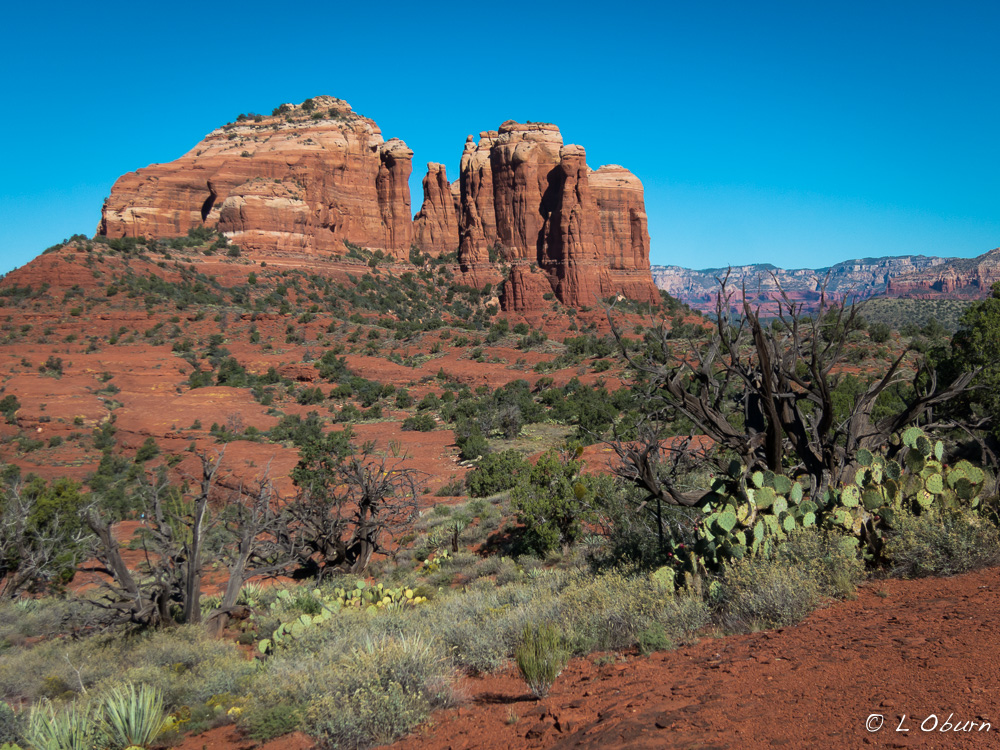
Views of one of the most-photographed sights in Arizona, Cathedral Rock, can be seen from many angles, and we soon found ourselves getting off our charted course to see if we could pick up a trail that would take us to the highest saddle point on Cathedral Rock.  There is a designated, slick rock trail up to the saddle point but it was on the opposite side of Cathedral Rock from where we were.  But did that stop us?  Nope!

Although we would not suggest this as the soundest or safest way to get to the saddle of Cathedral Rock, what with the bush-whacking and boulder-hopping, it was certainly a unique approach.  What began as a moderate 5-miler ended as a very interesting 9-mile hike.

Our next day’s adventure was to be a bear and Terry’s all-around favorite Sedona hike.  After tackling this mountain, I had to agree.

2)  Bear Mountain

I’m not sure why I never hiked this mountain while we lived in Sedona, as it has always been touted to have some of the most breathtaking views from its peak.  I had decided this visit was the time and I wasn’t leaving Sedona until I had firmly planted my feet on top.  All I can say is wow!

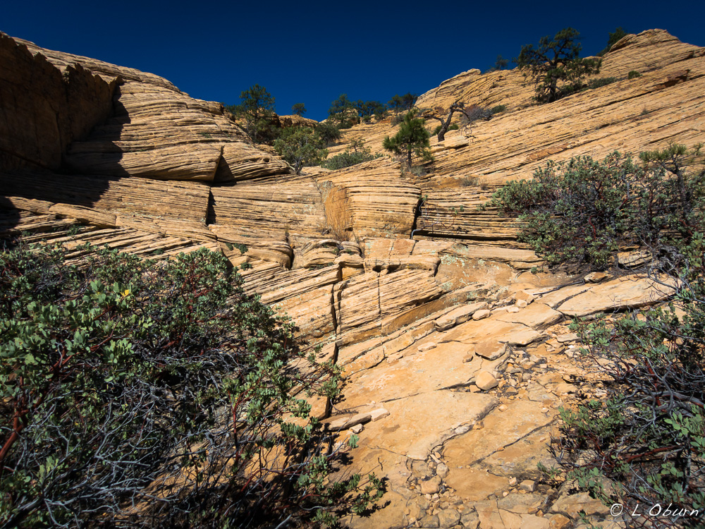
Bear Mountain is a 5-mile hike with a 2000 foot elevation gain over some of the most unusual topography in Sedona.  There are cairns to mark part of your journey but white arrows painted onto the rocks are your true guides to the peak.  There are interesting breaks or decks of changing geology that you pass through, almost as if you traverse three false summits before reaching the true peak.  A section of Apache Limestone moves into Schnebly Hill Sandstone, then onto a deck of swirling Coconino sandstone dotted with manzanita, truly spectacular.

Sedona’s grandeur can be seen without taking to the trails, but we have always believed that the essence of her spirit lies off the paved roads, tucked back into her hidden canyons.

We have settled into our winter home in Southern California, which I will post about in the near future.  It is a change from our existing approach to RVing and we are enjoying it more than I had imagined.  More on that later…

Bizarre, Broken, Bewitching ~ Theodore Roosevelt National Park (Part 2)

“The Badlands grade all the way from those that are almost rolling in character to those that are so fantastically broken in form and so bizarre in color as to seem hardly properly to belong to this earth.”  ~ Theodore Roosevelt

Storm clouds build over the Little Missouri

The Badlands story, of which Theodore Roosevelt National Park is a part, began over 65 million years ago.  While the Rocky Mountains were rising from the earth, bucking and writhing to claim their place in the landscape, massive amounts of sediments were being carried east on the wind and in the water, creating this desolate mural.  Savagely erupting volcanoes in surrounding states were belching ash to combine with the Rocky Mountain sediments.  The badlands are the result of layers of sandstone, mudstone, siltstone, and bentonite clay air-brushed into unusual rock formations and vivid striated buttes.

This national park was once on the eastern edge of a swamp and over time these sediments compressed and broke down, causing chemical changes that resulted in the formation of lignite, a soft coal that Teddy Roosevelt shoveled into his stove to heat his home.  In these striated buttes, lignite can still be seen.  Lightning strikes and fires cause the lignite to smolder, which in many cases can continue underground for years. The hardened red-brick caps, known as “scoria”, seen on many rock formations, come from the oxidation of iron released from the burning of this coal.  The artistry of time, wind, and erosion have created the landscape we see today, which is constantly being transformed.

The 110 square miles of Theodore Roosevelt National Park cover three distinct areas of Badlands in western North Dakota and the Little Missouri River snakes through all of them.

  • The larger South Unit within the town of Medora, where we are camped
  • The smaller North Unit, ~80 miles north of the South Unit, off Hwy. 85
  • Roosevelt’s Elkhorn Ranch located between the two.  Only cornerstones remain there today.

Both the North and South Units have similar topography and many of the same wildlife, deer, bison, prairie dogs.  The North claims the longhorn steer and bighorn sheep, while the South boasts elk, pronghorn, and feral horses.  I had also read about a phenomenon in the North Unit that Nina had introduced us to while on the coast of Oregon that has enchanted me ever since – concretions.  I knew a trip up north was in my future.

On a rare sunny, rain-free day I pointed the car north on the hunt for longhorn steer and cannonball concretions.  While the steer remained elusive, I found the concretions hiding in the shadows.

I could have gone back south and been happy but I had the day so a couple of hikes and a visit to a prairie dog town seemed in order.  I chose the Caprock Coulee Nature Trail and the Buckhorn Trail, taking me through open prairie, aromatic sagebrush, canyons with unusual rock formations, and a town where only prairie dogs are welcome, as they will let you know if you get too close.

Our visit has been more rain than sun and locals say this part of ND has had a very wet summer.   On one of those cloud-filled mornings I headed out bright and early, hoping to get a hike in before the rains came.  My goal was to tackle part of the Maah Daah Hey, a trail that stretches 97 miles across the National Grassland, connecting all three units of the park.  Over 7 miles of it runs through the South Unit, just a couple of miles from our campground and it’s a great trail for hiking and mountain biking.  Plans were thwarted when I got to the Little Missouri, a necessary water crossing I thought would be easy.  Given the recent rains we have had, no way was the river allowing me passage. 😦

On a rare rain-free evening I ventured into the park hoping to catch a memorable sunset on top of Buck Hill, noted for its dramatic evening views. Although the sunset didn’t wow me, what I spotted around a curve in the road did…the feral horses!

And although the sunset wasn’t spectacular, it was a nice ending to my stay at Theodore Roosevelt NP.


Rugged, Desolate Beauty ~ Theodore Roosevelt National Park (Part 1)

“There are no words that can tell the hidden spirit of the wilderness, that can reveal its mystery, its melancholy and its charm.”  ~  Theodore Roosevelt

Clouds dance across the Painted Canyon, first stop in the park off Hwy. 94

Theodore Roosevelt National Park, named after our 26th President of the same name, lies in western North Dakota.  Part of Teddy’s spirit may still roam here, given his love for this land, for it was his time spent here that played an instrumental role in his development of conservation policies that remain in place today.

The Lakota people were the first to call this territory the “badlands” due to lack of water, extreme temperatures, and the rugged terrain.  Teddy Roosevelt first came to the North Dakota Badlands in September 1883 to hunt bison and was enchanted by its desolate, melancholy beauty.  It was the death of his beloved wife Alice Lee, due to complications from childbirth, and mother Mittie, who succumbed to typhoid fever, both in the same house, on the same day, February 14, 1884, hours apart, that brought Roosevelt back to these lands, heartbroken and seeking nature’s healing powers.

Bison freely roam these plains.

We entered the gateway town of Medora on a hot, muggy day so we chose the 36-mile scenic drive of the South Unit over hiking that first afternoon.  After spending much time in similar parks, such as Yellowstone and Yosemite, this park (imho) paled in comparison.  But the expression “don’t judge a book by its cover” applies here, as in digging a little deeper I have found some hidden gems.  But before I get to the good stuff, I’ll share a bit of a saga that’s been going on behind the scenes here.

Terry taking in the views.

Unfortunately the day of our arrival we learned just how much Terry’s father’s health had deteriorated over the past few days.  We both felt it imperative that Terry head to Ohio now instead of wait until the 25th of this month as he had planned.  What to do about an airport and flight was the next question, as we are in the middle of nowhere. The closest “big” town to us is Dickinson, 40 miles away, but surprisingly learned they have an airport another 7 miles outside of town.  So with flight booked and bags packed, we headed for the airport the next day, a very rainy day at that.

With Terry safely at the airport, I headed back to the park.  As I approached Dickinson a message scrolled across my dashboard stating STOP SAFELY NOW, and within seconds the truck decided to stop me.  There I sat in the driving rain blocking traffic, which never makes for happy drivers. With Terry at the airport contacting Ford and a tow service, I directed traffic while drivers scowled at me through rain-streaked windows.

Fast forward and an easy fix soon became anything but as the sensor broke while being removed so now we are awaiting parts and dealing with a warranty company that has been less than cooperative.

Many hours later, in a rental car headed back to the park, the skies opened and I found myself wishing for an ark.  Suffice to say the drive back at 40 mph was the longest 1.5 hours I have spent in some time.  I later learned that we had received 6-8″ of rain in a matter of two hours, which is probably why I felt I floated home most of the way.  But Terry is where he needs to be and I arrived safely.

The silver lining in this ongoing saga was a visit from dear Colorado friends Stan and Marilyn.  For two days we enjoyed great conversation, lots of laughs, and a lovely hike. They agreed to a hike I really wanted to do in the remote northwest corner of the south unit, the Petrified Forest Loop Trail. I was determined to hike it solo or with friends but agreed that it is probably best done with others, especially if the solo woman is somewhat directionally challenged. 😉  The petrified forest, hard sandstone spires topped with caprocks, and dodging bison during their rut made for an interesting hike.

We rounded out our time together with a stroll through Medora and a lovely dinner at Theodore’s, which we all highly recommend.   The food was excellent and the company, of course, priceless.  I can’t thank them enough for brightening up my week.  We look forward to seeing them again soon in Colorado.

Next up:  More hiking, prairie dog towns and concretions, my favorite!

Shifting, Ever-Changing ~ White Sands National Monument ~ Alamogordo, NM

As we looked west to the San Andres Mountain range rising from the desert floor, wave after wave of blinding white seemed to stretch as far as the eye could see, rolling out to the horizon.  We had arrived at one of the world’s great natural wonders, White Sands National Monument.

miles of white sand

Approximately 15 miles outside of the town of Alamogordo, New Mexico lies the world’s largest gypsum dune field, 275 square miles of white, glistening sand dunes, ever-shifting, ever-changing.  Technically this should not be here, as gypsum is soluble in water, which makes it a very rare form of sand.  Typically, rain and snow high in the mountains carry dissolved gypsum to rivers, which then flow to the sea.  But the Tularosa Basin is not typical; no river drains this desert land so the gypsum that collects here becomes trapped, along with various other sediments.

During periods of rain or snow, water evaporates in the Tularosa Basin, breaking the gypsum down into a crystalline form known as selenite.  Freezing, thawing, wetness and dryness break the crystals down even further into fine grains of sand.  As the wind tosses them along the ground, theses tiny grains crash into one another, scratching their surface.  These scratches change the way light reflects off the sand particles, causing them to appear white.

White Sands is a living laboratory, providing scientists an understanding into our past and a peek into our future, as they explore the gypsum dune field on Mars.

As we drove the 8-mile loop road through the monument, we had the feeling we would begin sliding at any moment, as it appeared we were driving on an icy, snow-packed road, with snowdrifts as far as the eye could see.  I wondered what keeps dunes like this, so exposed to the wind and weather, from simply blowing away.  New Mexico does have its fair share of high winds with so much open desert.  I learned that the dunes can shift west to east up to 30 feet per year but it is ground water, found 12-36″ below the surface that keeps the dunes at 100% humidity year-round, helping to stabilize these massive sand piles.

Looking out over this vast expanse of white, you would think that nothing could live here, but many species of plants and animals do just that, having adapted and evolved over time to a white pallor that provides the perfect camouflage.  The bleached earless lizard is one who is coping well to a life without color.

Terry, looking out over the Sacramento Mountains, at sunset

Many come here to slide down the massive dunes, purchasing wax-coated sleds in the visitor center’s gift shop.  I decided to let the kid in me run barefoot up and down the dunes, while Terry, who had cut his toe earlier in the day, kept shoes one, shaking his head as he watched me run up one dune and down another.

As the sun began to dip below the San Andres Mountains, we sat watching in awe, as this wonder of nature was wrapped in a golden glow.

Sunset over the San Andres Mountains

If you liked this blog post, why not scroll up to ‘Follow Us’ and enter your email address?  You just might find something that interests you.


Chiracahua Mountains ~ Hoodoo You Think You Are?

Chiricahua Mountains…ancient homeland of the Apache, sky island, “Land of Standing-up Rock”?  The Chiracahuas are all this and so much more.

Chiracahua Mountain Range

As I walked among the towering hoodoos I marveled at the fact that we spent 25 years of our lives in Phoenix and Sedona and had never traveled to the Chiracahuas, being the hikers we are.  Granted, it is not a short jaunt across town,  just 50 miles north of the Mexico border, but the mountains are so breathtaking and the history of the area so rich, I’m not sure why we waited.  Perhaps we just needed to be a little more seasoned to appreciate all that is here.

The Chiracahua Mountain range had its origins roughly 27 million years ago, when eruptions from the Turkey Creek volcano spewed ash over 1200 square miles.  This sky island, which is essentially an isolated mountain range rising above a grassland sea, developed over many millenia into the rock pinnacles that we see today.  They stand like guardians of the forest and send the clear message that you are now in Chiracaqua country.

The Chiracaqua Apache claim this land as their ancestral home, with evidence of their existence in these mountains dating back to the early 1400’s.  They named this range the “Land of the Standing-Up Rock” and lived peacefully here until the Europeans stepped in to declare this land theirs.  Led by Cochise and Geronimo, the Apache staunchly defended their ancestral homeland.  The last of the Apache finally gave up the fight in 1886, surrendered, and were later relocated by the government to Oklahoma and New Mexico, never to return to this sacred land. So much more could be said here but I will just add that I felt a sadness as I walked the trails, reflecting upon all the Native Indians have so unjustly lost .

There is such an interesting blend of local and exotic plant and animal species here that it is said to be one of the most biodiverse regions in North America, boasting over 1200 species of plants alone.  Plants and animals from four different ecosystems come together in this range.  Birders flock here for the diversity as well, seeing many species of birds that can normally only be seen in Mexico.  We visited for the hiking, to witness Mother Nature at her finest, rock formations precariously balanced in such a way that it appeared a strong wind could topple these giants.

Chiracaqua National Monument was established in 1924 to preserve and protect these 12,000 acres and in 1934 the Civilian Conservation Corps began to tackle the job of roads and trails.  Today there are ~20 miles of trails for your hiking pleasure and 86% of this sky island lives on as pristine wilderness.

To experience as much of the Chiracaquas as we could in one visit, we chose the Big Loop, a combining of many trails that resulted in a lovely 10-mile hike.  There are a few ways you can tackle this trail and, based on a tip provided to us by a Park Ranger at Fort Bowie the day before, we elected to take the shuttle from the visitor center to the Echo Canyon Trailhead (arrive prior to 8:30 am).  From there we followed this route:  Echo Canyon Trail> Hailstone Trail > Mushroom Rock Trail > Big Balanced Rock Trail > Heart of Rocks Loop (where most of the named formations stand) > Sarah Deming Trail > Lower Rhyolite Canyon Trail. This and a little other meandering will get you a fabulous 10-mile hike, with the last three miles being downhill. 🙂

Heart of Rocks Loop:

Wandering among these geologic wonders that time and weather have painstakingly created, you just might feel the spirits of the ancient ancestors who walked this ground…truly a sacred experience.

If you liked this blog post, why not scroll up to ‘Follow Us’ and enter your email address?  You just might find something that interests you.