“There’s nothing more beautiful than the way the ocean refuses to stop kissing the shoreline, no matter how many times it’s sent away.” ~ Sarah Kay
As holiday madness begins to wrap its crazed tentacles around us, even the most imperturbable beings may find themselves taking deep calming breaths. Since our anniversary immediately followed the Thanksgiving holiday this year, hubby decided to surprise me with a three-day beach getaway to Encinitas. How could I refuse?
Photo bombed by an errant shorebird.
Given that our bodies are about 60% water; the same percentage of salt in our blood is what exists in the ocean; about 70% of our planet’s surface is water; and water is essential to life, it is not surprising that most people are inexplicably drawn to the sea, even if they don’t swim or even enjoy sticking their toes in the water. What is it about the sea that draws us in?
I recently read an article by marine biologist Wallace J. Nichols on the theory of our “blue mind”, a “mildly meditative state characterized by calm, peacefulness, unity, and a sense of general happiness and satisfaction with life in the moment”, elicited when we are in or near water. “We are beginning to learn that our brains are hardwired to react positively to waterand that being near it can calm and connect us, increase innovation and insight, and even heal what’s broken,” Nichols explains. When we humans think of water – see water, hear water, immerse ourselves in water, we feel something.
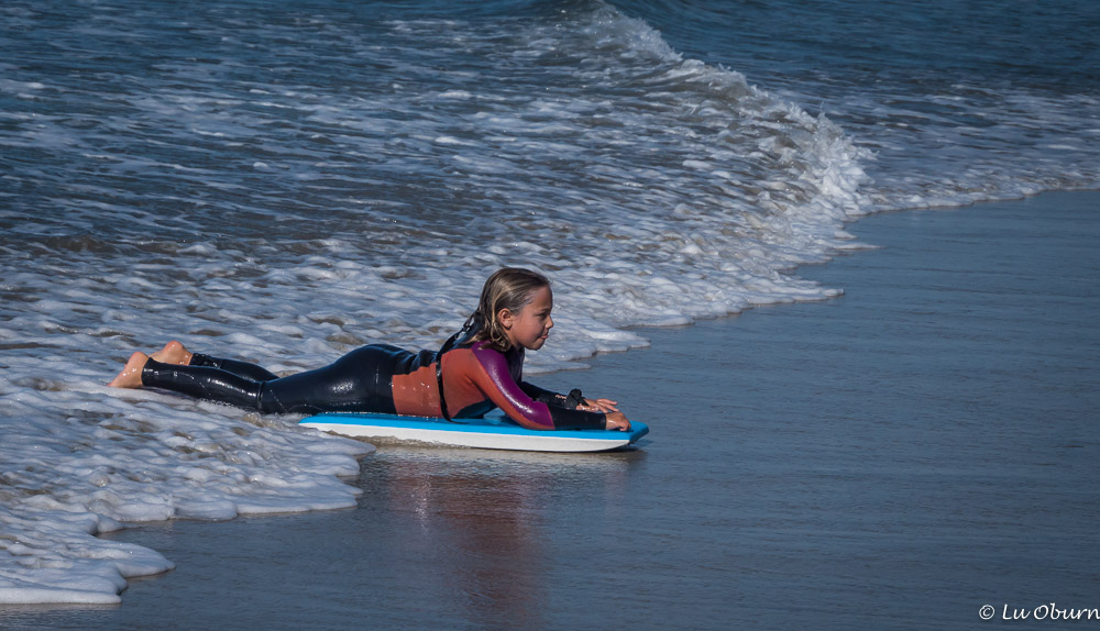
Undoubtedly, children feel joy…
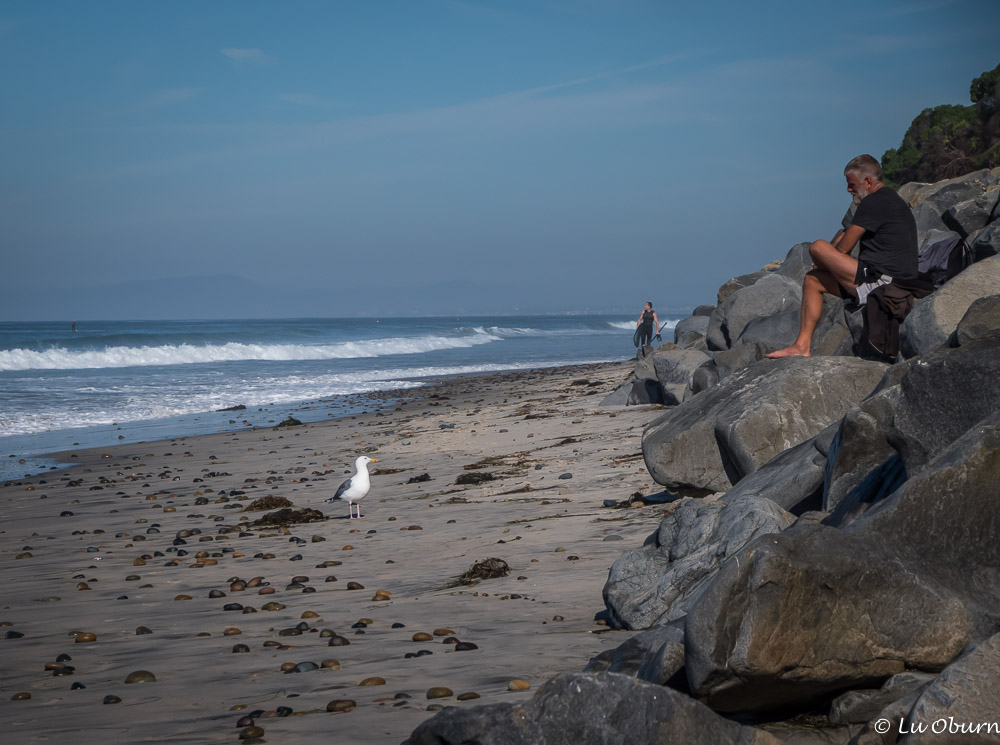
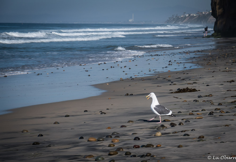
And birds, well who knows…
Begging for a morsel, or a sandwich would be nice.Expressing his displeasure walking away empty-billed.
I cannot deny nor begin to explain the serene turbulence I feel as I listen to the hypnotic sound of polished rocks being flung to the shore and drawn back out to sea by the powerful movement of the waves. With each breath of salty sea air, my entire being courses with an electric current of emotion. Gazing out across the water at the horizon, I imagine what lies beyond. I am reminded of how small I am and how insignificant my worries.
Feeling perfectly balanced.
Our three-day getaway was just the rejuvenating respite needed.
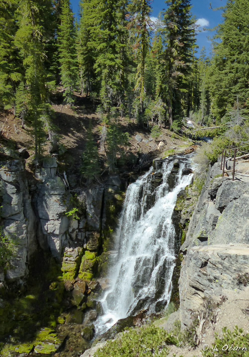
Our last stop in California, Lava Beds National Monument, lies at the remote northern end of the massive Medicine Lake Volcano. During the past half-million years this shield volcano has erupted many times, spewing gas and lava, creating an otherworldly landscape. It is still considered tectonically active, having last erupted ~ 950 years ago. Today you can explore the resulting geologic features – lava tubes, spatter cones, and surface lava flows. The caves were created by lava flowing 10,500 to 65,000 years ago.
Lava Bed’s historic turbulent past mimics its geologic turmoil. Early Euro-American settlers uprooted the peaceful Modoc tribe who lived on this land, forcing their move to the Klamath Indian Reservation, yet another sad time in the history of our nation. Modoc leader Kientpoos, better known as Caption Jack, came back to the reservation with a band of 150 men, women, and children, determined to take back their sacred homeland. The resulting tension between the Modocs and the settlers brought about the Modoc War of 1872-1873.
The natural fortress where the Modocs retreated, known as Captain Jack’s Stronghold, remains today, a tribute to the fortitude of 60 warriors who held off a much larger army force for five months.
There are over 500 lava tube caves in Lava Beds National Monument, the highest concentration in the U.S. These tubes formed when the outer edges of lava flows began to cool, eventually creating a roof, much like surface ice on a flowing river. If multiple flows followed one channel, lava tubes were created atop one another, like stacked pipes. When the ceiling collapsed from its own weight, access was opened to the caves below. Twenty of the 500 lava tube caves are considered developed, with forged paths through them, ready to explore, rated from least challenging to most challenging.
Entrance to Skull Cave, where many animal and human remains have been found
We have been in many caves during our travels, Kartchner and Carlsbad, to name a couple. I have enjoyed them immensely but they had a few items that were missing in the Lava Bed’s caves, namely large-domed chambers, smooth walking surfaces, lighting and a ranger to show me the way. For someone who is claustrophobic, this was going to be a challenge.
Entering Indian Well Cave
Heading down into Labyrinth Cave
The lava caves are important habitats for 14 different species of insect-eating bats. In the summer female bats raise their pups in maternity colonies and in winter the caves become refuges for hibernating bats. Other critters slithering through the caves, which I tried not to think about when we were inside, are cave crickets, millipedes, and rubber boas, yet another reason for me not to explore the most challenging caves on my hands and knees.
Many of the caves, no matter the temperature above ground, remain at a cool 55°F. Some exhale frosty breaths that stay below freezing, with year-round skating rinks on their floors.
Entrance to Mushpot Cave
The Visitor Center recommendation for number of light sources in the caves is three flashlights per person. Perhaps this is more for those phobic-souls who would have a complete meltdown should they have a light malfunction. We carried three total, two that we rented from the Visitor Center and one of our own.
Fleener Chimneys, spatter cones that built up as hot gases threw globs of lava into the air
Closed-toed shoes, long pants and a hard hat were also suggested. We passed on the purchase of the hard hats and opted for ball caps instead since I didn’t see the need for hard hats in our future. But, if you bang your head on a low-hanging ceiling, as I did, you might begin to think that a hard hat would be a nice prop to have when you have a yearning to belt out ‘YMCA’. 😉
We explored six caves in the least to moderately challenging categories and poked our head into another in the most challenging. Sentinel Cave, 3280′ in length, was the longest 30-minutes of my life and deathly quiet, with only my occasional outbursts of “I don’t know if I can do this” spoken into the black void.
Golden Dome was the most interesting, with beautiful colors reflecting off water droplets that beaded up on a coating of hydrophobic bacteria. This cave can also be a bit disconcerting as you encounter a figure-8 that could keep you walking in circles if you didn’t pay close attention.
So, would I venture into these caves again? Surprisingly, yes I would, if you didn’t ask me to do it on my hands and knees. 😉 If you like cold, damp, dark places where the only sounds are the occasional dripping water and your own raspy breaths, this might be something you too would enjoy. It it really pretty awesome when you think about how these unusual caves were formed.
Advice from a Volcano: “Stay active; keep your inner fire burning; it’s ok to let off steam; go with the flow; be uplifting; it’s all a matter of time; have a blast!” ~ Ilan Shamir
After living in Yellowstone National Park for two years, I became fascinated with the powerful forces of nature at work below the Earth’s surface, so it was not surprising that I was drawn to the “lava-strewn” landscape of Lassen Volcanic National Park.
Lassen Peak with Manzanita Lake in the foreground
All rocks found in this park originated from volcanoes and all four types of volcanoes can be found here: shield, cinder cone, composite, and plug dome. The main peak in the park is 10,463’ Lassen Peak, a plug dome volcano, formed when lava is too thick to flow a great distance so rises directly over the vent to form a dome. She is a beauty and can be seen from many vantage points throughout the park.
May 22, 2015 marked the centennial of the Lassen Peak eruption, a cataclysmic event that blew a cloud of ash almost six miles into the atmosphere. Volcanic ash rained down over 200 miles to the east and boulders weighing as much as 300 tons were carried five miles from the peak. This explosion set the stage for establishing Lassen Volcanic National Park in August 1916.
Seismologists continue to study volcanic activity within the park. Earthscope, a plate boundary observatory station, is part of a network of over 875 stations installed across the western U.S. to study movement of the Earth’s crust.
Lassen Peak viewed from Devastated Area
We stayed at Manzanita Lake in the northwestern part of the park, the only open campground when we arrived on Memorial Day. Lassen is one of the lesser-visited National Parks, possibly because it is a bit “off the beaten path”. With so much beauty and so much to offer, we found ourselves wishing for more time. A return trip is in order, as we felt we had only scratched the surface in 4 days.
Here is what we were able to squeeze into our short visit:
1) Manzanita Lake Trail – a tranquil 2-mile trail that is a must at sunset. Go at various times of the day and you will find something new at each visit.
2) Manzanita Creek Trail – a 7-mile obstacle course of fallen logs across the trail, caused by a severe windstorm earlier in the year. This was a ranger recommendation but the only positive for us was that it could be done from the campground.
Manzanita Creek Trail strewn with downed trees
3) Summit Lake Trail – The entire trail is an ~ 11-mile loop, with lots of crystal blue lakes. We did 7.5 miles to Lower Twin Lake, which brought us past four of them. We would have liked to complete the entire loop but Terry had taken a nasty fall a few nights before and did a fine job bruising his ribs. It seems climbing over downed logs on the trail wasn’t helping them much. 😉 Needless to say I had to hike on my own for the rest of our stay in Lassen.
Summit Lake
4) Kings Creek Falls Trail – a 3-mile trail down to a large waterfall. The foot trail was closed due to poor trail conditions so partway into the hike you were diverted to the horse trail, a steep rocky descent down to the falls. This hike had great views of Lassen Peak and the falls were quite lovely.
Kings Creek Falls
5) Road Trip – We drove the winding 30-mile main park road from north to south…gorgeous!
Lassen Peak Trail closed due to snow
In the foreground of Brokeoff Mtn.
Hissing steam vent at Sulphur Works
A few items on our list that will have to wait for another visit:
Lassen Peak Trail – closed due to snow
Bumpass Hell Trail – closed due to snow
Cinder Cone – a hike to the top of a dormant volcano
Devil’s Kitchen – lots of geothermal activity in this area
Mills Creek Falls – tallest waterfall in the park
185-mile scenic drive beginning in the town of Chester, meandering through forests, geothermal springs, craggy peaks, and lava fields of Lassen National Forest and Lassen Volcanic National Park.
Lassen Volcanic National Park has a quiet calm to it when you gaze upon its stately pines, jagged peaks still swaddled in deep blankets of snow, and crystal lakes. Yet far below the surface a fire still burns, evidenced by the hissing steam vents, bubbling mudpots and boiling springs dotting the landscape, symbols of nature’s powerful forces and diverse beauty.
One of the oldest lakes in North America, at least 760,000 years old, can be seen along Hwy 395 at Lee Vining, near the eastern border of Yosemite National Park. It is the enchanting, mysterious Mono Lake, one of the most productive lakes in the world. Mark Twain dubbed this lake the “Dead Sea of California”, but he could not have been more wrong. Not too many species can survive in this harsh environment but those that have adapted do so in prolific numbers.
Fed by five streams, underground seeps, and the Sierra snowpack, Mono Lake has no outlet. Because of its inability to release water, it is three times saltier than the Pacific Ocean, an extremely alkaline condition.
If you were to swim in Mono Lake, and you can, you would be so buoyant you would bob up and down like a cork in water. As a comparison, below is the saline count of a couple of well-known bodies of water:
Lake Tahoe – 0.001% salt
Pacific Ocean – 3.5% salt
Mono Lake – 10% salt
To convert Lake Tahoe’s waters to that of Mono Lake, you would need to add the following to one quart of water:
2.5 tablespoons table salt
1.5 tablespoons baking soda
2 tablespoons Epsom salts
a pinch of borax
a pinch of detergent
Is it any wonder that fish cannot survive in these waters? It is amazing to me that anything can. However, brine shrimp and alkali flies seem to like these salty waters just fine.
During the early spring months, the lake is “as green as pea soup”, due to the microscopic algae bloom. As the water warms, recently hatched brine shrimp and alkali flies feed on the algae. By summer they have consumed so much algae that the lake water becomes clear and returns to a blue color once again.
In the warm summer months, an estimate of 4-6 trillion brine shrimp swim in these waters. Alkali flies live along the shore and walk underwater, encased in small air bubbles for grazing and to lay their eggs. These two Mono Lake inhabitants are an important source of food for the millions of migratory and nesting birds who find their way to this salty sea.
Interesting chemical reactions occur when freshwater springs (calcium) meet alkaline water (carbonates). Calcium carbonate (solid limestone) is the result, better known to geologists as a tufa. These hauntingly beautiful formations have their beginnings underwater and continue to grow as freshwater and lake water meet. There is evidence of Ice Age tufa at Mono Lake, which grew beneath the water nearly 13,000 years ago. They have a crystalline structure that differs from more recent tufa. Mono Lake’s “petrified springs” are a fascinating example of what nature can do with a few basic ingredients.
Many photographers come to the South Tufa to capture these unique limestone statues. The best time for photos is at sunrise, if the sun makes an appearance, and she has been a bit timid these past several days.
At its height, Mono Lake soared to a depth of 900 feet, but now its average depth is a mere 50 feet, with a maximum depth of 150 feet. The lake is currently seven vertical feel lower than its targeted level. About 45” of water is lost annually to evaporation, so freshwater inflow is critical to its health. Although we have been less than enchanted with the rain, sleet, and snow flurries that have pelted this area during our visit, we are comforted knowing that Mono Lake is the better for it.
We begin our journey north in search for warmer temps, as we can’t seem to will the thermometer to move beyond the 50 degree mark yet.
Bishop, largest populated city in Inyo County, sits at the crossroads of well-known Highway 395 and Highway 6. It has a small town feel as you walk its streets, meandering among long-time locals, hippies with dreadlocks and weathered backpackers. With all Bishop has to offer, it may well be the most popular stopping off point along the Highway 395 corridor.
When I think of Bishop, this is the scene I first envision.
We had planned several days in Bishop before we headed out for the summer as we wanted to experience this bustling little jewel in the spring, but our stay has been longer than anticipated as Mother Nature has decided she is not yet done with winter in the Sierras. So what is there to do in Bishop when you are waiting out storm fronts? Here are our top 3 picks:
1) Feasting
Bishop is the foodie paradise on the 395, with over 40 restaurants covering any type of meal a discerning palette could want. We followed Nina’s lead on this one.
Any guesses whether we ate the whole thing?
Bishop Burger Barn – offering a wide choice of burgers on homemade buns (even gluten-free) and grass-fed beef, the barn is a must if you love a good burger. Be forewarned, you could blow your daily allowance of calories in one sitting. We opted to bike out to the barn and felt just a wee bit comforted by the fact that we burned off a few extra calories, but definitely not as many as we consumed.
Mountain Rambler Brewery – new to town, with four of their own brews, one being a porter…yeah! They are working on eight more taps and will surely improve over time.
Terry, Tom, & Z at Mountain Rambler Brewery
The best part of our time at the brewery was meeting new full-timers Zsuzsa (better known as Z) and Tom. Z is from Hungary and they are a delightful couple. We learned during our visit that it was their 5th-wheel that was parked next to Dragon Face Rock in the Alabama Hills when I was respectfully trying to capture a photo without encroaching on their campsite. Facebook brought us together from there.
Great Basin Bakery – go for the cookies, especially the Sierra Mud and Molasses…amazing!
Thai Thai Restaurant – another meet-up with Z and Tom. We had eaten here during our last visit…tasty!
One last meal with Z & Tom before we leave Bishop.
2) Window Shop or Contribute to the Bishop Economy
There are lots of little boutique shops in which to spend your hard-earned money. Here were our top three favorites.
Mountain Light Gallery – If you are the least bit interested in landscape photography, you should not miss out on the opportunity to visit this fabulous gallery, a tribute to the magical, one-of-a-kind photography of Galen Rowell and his wife Barbara. We spent hours here during our last Bishop visit and did so again this time.
Wilson’s Eastside Sports – fabulous products, wonderful clerks and Terry is the proud owner of new hiking boots.
Spellbinder Books – a quaint bookstore with a variety of new and used books.
3) Hiking, Bouldering, Rock Climbing (now we’re talkin’)
There are plenty of high elevation hikes to consider but since the winter storms keep rolling in, this has been out of the question. It has made for some beautiful mountain photos but is not conducive to hiking. We did get our high altitude fix in when we last visited in the fall, which you can read about here.
Bishop, unbeknownst to us, is one of the top rock climbing places in the world, offering over 2,000 bouldering “problems” for all climbing levels.
Afternoon light in the Buttermilks
Expansive views
Gigantic egg-shaped boulders to entice climbers
Gigantic granite egg-shaped boulders dot the landscape in the Buttermilks, challenging the very best climbers. It is said that the open windswept nature of these mountains will freeze your skin before your muscles give out. The vistas are breathtaking, the hiking wonderful, and we were greeted by some interesting characters on the way back to our camper.
I think he likes bouldering!
Takin’ a bath in buttermilk!
A lovely new friend
The patriarch of the herd
Beautiful, gentle arctic wolf
In the Volcanic Tablelands, where we spent several days boondocking, the volcanic tuff of the Happy and Sad Boulders present countless bouldering opportunities. The “Happies” have a larger choice of boulders and the “Sads”, less visited, have a dense population of more difficult problems. We visited both and the rock formations were spectacular. We hiked from where we camped and took the long way home, making for a 7-mile day of hiking and bouldering…fun times.
Not a soul in sight in the Sad Boulders
Joining in on the fun
Spiderman in his “older” years, still rocking’ on!
A climber studying his route. We were told most use the pads shown on the bottom right.
Still a bit of a daredevil in him!
As of this writing we are still in Bishop, hoping for a break in the weather further north. It looks like spring here, with temps hovering near 70 degrees but the snow-capped mountains all around us tell another tale of what to expect on the mountain passes. If we stay here much longer, we might get to experience Mule Days, Bishop’s week-long festival held since 1969 celebrating the contributions pack mules have made to the area. It might be fun to see but fingers-crossed we will be heading north soon.
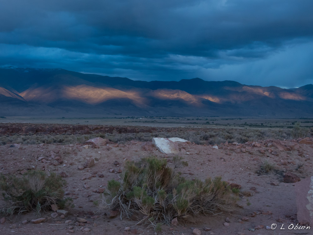
Blue hour in the Volcanic Tablelands before the storm