Puerto Varas ~ Land of Lakes and Volcanoes

30 March – 4 April, 2018

Although our time in Chaiten was mostly rainy, it may have been a  blessing, as I had fought off what I thought was a sinus infection for days, and although I didn’t feel bad, I knew my body would respond better with a little rest. That can be challenging to do on this type of trip, as Mother Nature and her moods tend to dictate when you do your exploring.

Travel day arrived and the sun made a rare appearance. This was to be a long travel day, three ferry rides and stretches of bus excursions that took us around and across many of the lakes dotting this area. When we saw the extent of the road construction during this phase of our journey, we were thankful we didn’t rent a car. The trench right outside my bus window was so wide and deep, one false move and it would have swallowed our bus whole. However, the scenery on the water was captivating and relaxing, and there was no holding onto the rail for dear life in fear of being blown off the deck. 🙂

Although our final destination was Puerto Varas, the bus station is in nearby Puerto Montt and this is where we spent the night, right next to the station at the Ibis Hotel. The next morning, we hopped into a taxi for a ride to the airport, where we rented a car for our stay in Puerto Varas.

Puerto Varas, dubbed the “City of Roses”, is a lively city of 38,000, in the Chilean Lakes District. It sits on the southwestern shore of Lake Llanquihue and holds commanding views of Osorno and Calbuco Volcanoes, both still considered active.  It is also the gateway to Parque Nacional Vicente Perez Rosales.

View from our bedroom window at Hotel Solace.

German colonial architecture has made Puerto Varas one of the most beautiful cities in southern Chile. We enjoyed walks along the lake and discovered during one of our wanderings a larger than life metal sculpture of a woman with outstretched arms, as if paying homage to the majestic, snow-capped volcanoes.

This is also the city where we finally found some restaurants that featured salads instead of the typical “heavy on the meat and cheese” dishes. It was a delightful change. La Gringa was one of our favorite places for lunch, feeling more like a Pacific Northwest café (including the rainy day) than anything else.

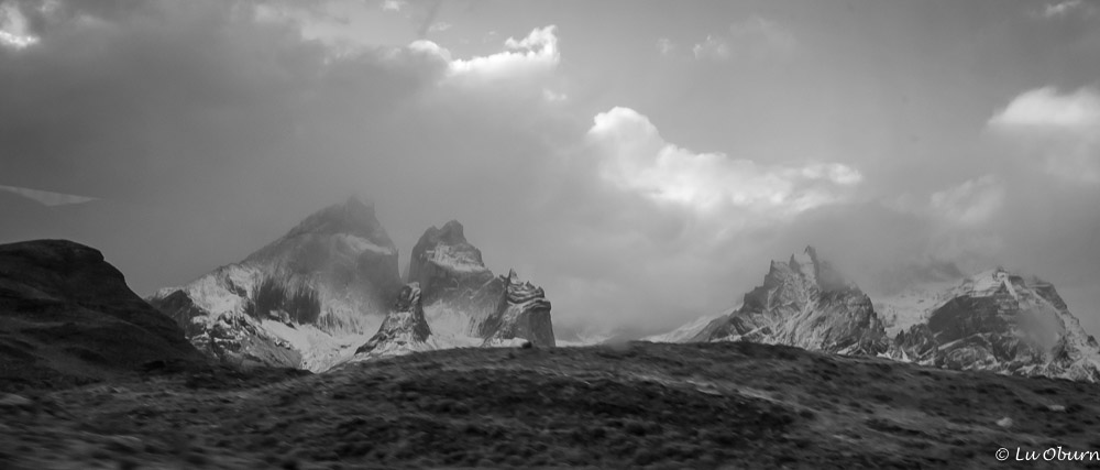
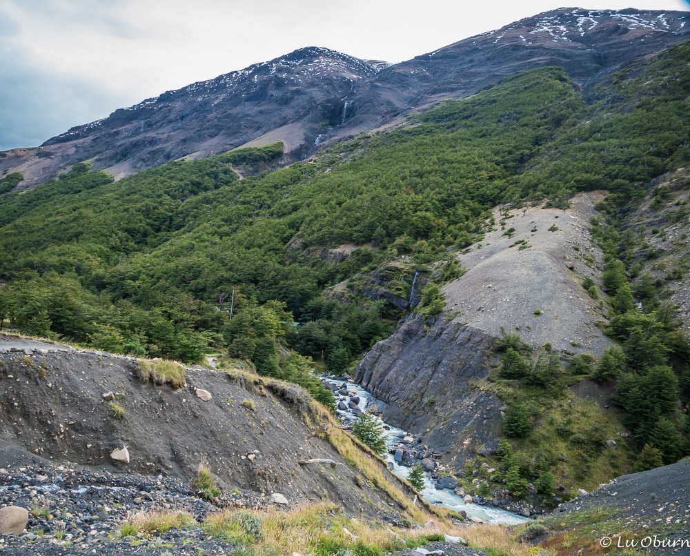
As I am slightly obsessed with national parks we decided to take a ride to Parque Nacional Vicente Perez Rosales, Chile’s first national park, and where we knew we would find some picturesque falls, the Saltos del Petrohué. This isn’t your typical waterfall, instead more a chute of crashing whitewater, a relentless pummeling cascade over basalt columns, polished shiny and smooth by volcanic runoff. It is also where some of the best views of Osorno Volcano, can be found. Although it hasn’t erupted since the mid-19thcentury, it still has some active fumaroles.

 A drive around Lake Llanquihue was also recommended, promising interesting little towns along the way –  Llanquihue, Frutillar, and Villa Ensanada.

On the southeastern shore of Lake Llanquihue, Llanquihue also has a noted German influence and celebrates “Bierfest” each January. One of the town’s main attractions are the many wooden sculptures sprinkled around town, created by both national and international artists.

Frutillar sits on the western shore of Lake Llanquihue and is well-known for its German architecture, its landscape, and beautiful gardens. The main attraction is Teatro del Lago (Lake Theater) and the annual summer music festival, “Semanas Musicales”, when several worldwide philharmonic and symphonic orchestras come together. Frutillar also boasts the best cake shops in the whole nation.

Villa Ensanada is a small, peaceful village on the southwest shore of the lake, where, on a clear day, you can see splendid views of Osorno and Calbuco volcanoes. It is also a hotspot for outdoor activities. We had a clear day!!!

I had seen photos of the “palafitos” on Chiloé Island, colorful fishermen bungalows balanced on stilts, in the city of Castro, so this was the destination for our final day of touring. Many of these palafitos have been converted to cafes, hostels, and boutique shops.

Chiloé, which means “seagull’s place” in Mapuche, the indigenous language, is where Magellanic and Humboldt penguins cohabit, the only place where this occurs. Since we had already taken two tours to penguin colonies, we didn’t feel we were missing out by not taking this tour.

Castro, the largest city on the island, is also where two of the four UNESCO World Heritage Site wooden churches can be found.

Puerto Varas was where we were on Easter Sunday. Both Terry and I remarked that this most holy of days was not celebrated in the reverent manner we had seen when we lived in Mexico and how we had read it is celebrated in Spain. It seemed to be just another day in the life of Chileans, which we found a bit odd.

Our time in Puerto Varas had come to an end. Although not one of the more physically active pieces of our journey, it was a lovely stop that I would highly recommend if you find yourself in Patagonia.

Next Up: Back to Argentina

SaveSave

SaveSave

SaveSave

SaveSave

SaveSave

SaveSave

SaveSave

SaveSave

SaveSave

SaveSave

SaveSave

SaveSave

SaveSave

SaveSave

SaveSaveSaveSave

SaveSave

SaveSave

SaveSave

SaveSave

SaveSave

SaveSave

SaveSave

SaveSave

SaveSave

SaveSave

SaveSave

SaveSave

SaveSave

SaveSave

SaveSave

SaveSave

SaveSave

SaveSave

SaveSave

Carretera Austral ~ What We Have Learned

24 March – 28 March, 2018

Ruta (Route) 7, aka the Carretera Austral, is the only highway that runs through the northern section of Chilean Patagonia. Part of the Aisén region, starting in the Lakes District in Puerto Montt and ending 770 miles south at Villa O’Higgins, it is the least populated region of Chile, with only about 100,000 inhabitants scattered throughout its towns and villages. We had read that it is a natural wonderland of islands, mountains, fjords, lakes, and forests, crossing many protected natural areas, so of course we wanted to visit. We envisioned renting a car or “Wicked Van” in Puerto Montt and traveling leisurely at our own pace, stopping when Mother Nature’s wonders called to us.

After reading some less than flattering reviews of the condition of the Wicked Vans and calculating the cost of renting a car for 6 weeks, we scratched both of those options. Since we were traveling in the shoulder season, if we had van problems, who knew how long before another vehicle came along to assist us. Also, the drop-off fee for a rental car, if not returning it to the place you rented it, was at least as much as the total rental fee…wow! Our next option was to take buses through some stretches and rent a car for shorter periods in others.

Balmy day along Lago General Carrera

Our two-day stop in Chile Chico was relaxing and the apartment we rented right next to the ferry, which we would be taking into the interior of Chile and part of the Carretera Austral. Walking the quaint little town and enjoying happy hour from our living room, looking out onto Lago General Carrera, was a nice little respite.

Departure day to Puerto Ibanez was sunny but chilly, and very windy, not surprising for Patagonia. It was so windy that whenever I stood on deck for photos I had to wrap my arm around the rail to stay upright. The wind never ceases to amaze me here.

After a 2.5-hour lake ride, we hopped into a van and were whisked away to Coyhaique, a city where we had hoped to rent a car and spend a few days exploring. The weather forecast was nothing but rain for the next several days, so time to go to Plan C or D, as we didn’t want to be traversing mud-slick roads in a remote part of Chile, particularly because this is what we had read about the Carretera Austral:

“While this may be one of the continent’s loveliest roads – there’s no bad scenery – it’s still one of the most hazardous. Paved segments are steadily increasing, but blind curves in dense forests and sheer mountains, narrow segments with steeply sloping shoulders, and frequent loose gravel all require drivers to pay the closest attention to avoid head-on collisions, rollovers, and other accidents.”

 Coyhaique is a city of roughly 50,000, nothing remarkable and felt a bit gritty and run-down, so we were glad we were only doing an overnight here. The next morning, bright and early, we hopped a bus to Chaiten, and some of the rainiest weather we had experienced yet. We agreed that letting someone else maneuver these winding, mud-slick roads was best.

Queulat National Park

For someone who loves to be out in nature taking photos, this was a lesson in patience for me, as we traveled through Queulat National Park, known for its waterfalls and hanging glaciers, and I had to be content with watching the scenery move by through rain-splattered windows. The vegetation was changing from windswept steppe to something resembling a Costa Rican cloud forest, with elephant-ear foliage, broad-leaf ferns, and lichen clinging to everything.

The bus dropped us in Chaiten, a sleepy little town, where we had two days to decompress. We enjoyed getting to know Frederico, the proprietor at our hotel. He had spent time with the World Gymnastics Organization in Moscow in 1972 and 1973 and had lived and worked with Olympic hopeful gymnasts for 6 years in California, in Temecula of all places, very near where we now live. Frederico generously offered us a lift to the bus station the day of our departure.

Some sights we missed due to weather:

What we have learned…

  • Patience is an absolute must when traveling in Patagonia.
  • Weather is consistently unpredictable. Expect rain and high winds.
  • Transportation is also unpredictable, probably more so when you leave the busy season behind. Buses that ran several times per week may only run once a week, or no longer run for the season. If you don’t want to be stranded in a small village for a week, you may have to go to Plan B.
  • Always have a Plan B, C, and D.
  • If the weather forecast is promising, having your own vehicle is probably the best approach, although not the least expensive. If we did this trip again we would probably rent a car and focus on the Carretera Austral for 6-8 weeks, bringing a tent along when we couldn’t find accommodations in some of the smaller villages.

Even with all the twists and turns, Patagonia is magical.  Lots of adventures to come, so please check back. 🙂

National Trekking Capital ~ El Chalten, Argentina

17 March – 22 March, 2018

Although we enjoyed our time in El Calafate and hiking in Torres del Paine National Park, we were looking forward to experiencing the trails of El Chalten, in the northern sector of Los Glaciares National Park, and the best news of all, there was sun in our forecast. Another early morning bus ride, this one only three hours, and we were there!

Los Glaciares National Park peaks, seen from the park service office.

There have been a few places where we carved out some extra time, as we knew Patagonia was moody, the weather changing often during the day. El Chalten was one of those places and we spent six days enjoying her laid-back atmosphere.

We had read on several forums that if you only had one place to hike in Patagonia, El Chalten should be the place. Trailheads are at the edge of town and the national park is free. Contrast this to our time in El Calafate, where we had a 2-hour commute to the park and the entrance fee was $38 per person. What’s not to like?

As we made our approach into El Chalten, the granite needles of Fitz Roy rose from the surrounding landscape, a watchful sentinel over this quaint little town. This mountain has become a symbol for Argentine Patagonia and became even more so thanks to Yvon Chouinard. After his successful summit of Fitz Roy in 1968, with a USA team, he used its shape to inspire the logo for his clothing brand, Patagonia. At roughly 11,200 feet above sea level, Fitz Roy may not be the highest peak in Argentine, but it is considered one of the most technically challenging climbs on the planet, due to its vertical granite cliffs and how quickly the weather can change. To give an idea of this challenge, Everest averages 50 successful climbers per year, Fitz Roy only one.

El Chalten is an eclectic little town, easily walkable, with a permanent population of 1,100. But with the recent paving of a highway leading into town, it’s growing so rapidly that some feel it will become the next Calafate, with spiraling real estate prices. It reminded me a bit of Gardiner, Montana, some roads paved, some still gravel with their fair share of potholes, a very interesting place.

We had three glorious days of mostly sun and little wind, giving us many opportunities to hike, to see Fitz Roy and Cerro Torre up-close. Our hostel, Pudu Lodge, was situated on the edge of town, with access to many of the hiking trails just a block away…perfect!

Scouting out interesting, local restaurants is part of the travel experience, and El Chalten has a fair number of cafes, given its size. We had heard about the German owned La Cerveceria from Backpacker Steve, whose website we researched often during our trip planning.

They brew their own beer, which is the reason he encourages travelers to go. Yes, their beer was tasty, but their menu, although limited, was so enticing, we found ourselves going back time and again, four to be exact.  What we discovered was a quirky little eatery that featured all things homemade, beer to breadsticks and everything in-between.  We loved the local stew, locro, the salmon ravioli, the vegetarian empanadas, and the butternut squash stuffed with sautéed vegetables. For a country that relies heavily on meat, bread, and cheese, this was a delicious diversion. And the staff made us feel like family each time we walked through the door.

El Chalten was everything we hoped it would be, and I finally found a couple of Patagonia’s more lovely residents.

Next Up: Long Night’s Bus Ride

SaveSave

SaveSave

SaveSave

SaveSave

SaveSave

SaveSave

SaveSave

SaveSave

SaveSave

Blue Ice & Depth Charges ~ Perito Moreno Glacier

14 March, 2018

I could barely contain my excitement as we boarded the Always Glaciers tour bus, anticipating our third national park, Los Glaciares National Park, and one of Argentina’s most visited destinations, the Perito Moreno Glacier. Rain clouds teased overhead but I was remaining cautiously optimistic that the Argentina rain gods would be kinder to us. Weather is so fickle here in Patagonia, so no use expending negative energy worrying about that which I couldn’t control.

El Calafate is famous as the base for visiting this glacier and the southern sector of Los Glaciares National Park, the largest national park in Argentina. The park has been named a UNESCO World Heritage Site, has 47 large glaciers being fed by a giant ice cap in the Andes, and 30% of its mass is covered by ice. This is the world’s 4th-largest ice cap, excluding Antarctica, Iceland, and Greenland.

The sky cleared as we paid our entrance fee to the park. I was encouraged as I had read that Perito Moreno tends to be more active in sunny weather. We were hoping to experience calvings off the face of this massive beauty.

There are several ways to see this gal – from her many boardwalks, taking a one-hour boat ride along part of her stunningly blue face, or trekking across. Try as I might before our arrival, I could not convince any of the tour companies to allow Terry to trek on the ice, their age limit being 65, and no exceptions due to the insurance they carried. 😦 We opted to stay on the boardwalks as we felt our chances of seeing calvings might be greater.

Not the largest glacier in the park but the one with star quality, Perito Moreno upstages twice-as-long Glacier Upsala, who has picked up much more debris during her advance and is not the brilliant blue that characterizes Perito Moreno.

Unsullied Perito Moreno, a jagged mass of crevasses and knife-edged seracs, is one of only two advancing glaciers in all of South America, crawling forward at a rate of ~ 2 meters per day. Most of the massive glaciers cloaking the spine of the Patagonian Andes are retreating in response to global warming, according to Andrés Rivera, a Chilean glaciologist, all except for Perito Moreno and Pio XI in Chile.  Perito Moreno, at  30 kilometers long and 5 kilometers wide, overshadows all else, sitting in the largest of Argentina’s lakes, Lago Argentino. Over 50% of her bulk sits below the sea, for a total combined height of ~ 170 meters.

Over millennia, untold numbers of storms have deposited countless meters of snow, compressing this glacier into what we see today. As the ice pushes across the channel of Lago Argentino, a massive dyke of ice cuts off the Brazo Rico arm of the lake from the main body. The water pressure builds until the natural dam can no longer bear the weight, resulting in an explosion of ice and frigid water that rushes into the lake’s main glacial trough, flooding everything in its path, including El Calafate. This phenomenon has occurred fifteen times during the 20th century, then from 1988 until March 2004, silence.

There was an arch over this section until two days before our visit.

On March 14, 2004, the dam gave way, releasing an avalanche of water and ice, a fitting metaphor for the flood of tourists who invaded El Calafate in hopes of seeing this event. It is said that those lucky enough to witness such a spectacle have found it to be one of nature’s most awesome sights. The last event of this type occurred just two days before our visit. Although this would have been the ultimate, the 14-meter wall of water that descended upon El Calafate is the reason the Laguna Nimez Bird Sanctuary was closed due to flooding. 😦

As if acknowledging our sadness at the loss of seeing all those feathered charmers, Perito Moreno stepped up and performed mightily the day of our visit. From our boardwalk perch, we listened for the sound of the glacier calving. Once you hear a sound that resembles a small cannon, get prepared for the show. Camera should be on-the-ready or you’ll miss blocks of ice, weighing hundreds of tons, detonating off the glacier’s 74-meter face, crashing into what has been dubbed “Iceberg Channel” below. These frozen depth-charges trumpet the forming of a new iceberg.

And the walls came tumbling down! Terry captured this on video. 🙂

These massive calvings occur several times daily and we were fortunate to see several during our few hours on the viewing platforms. Imagine pieces of a 24-story building being blasted away by a small cannon and this is the sound you hear. Terry got some great video footage, but internet will not allow me to upload it at this time. I see another Perito Moreno post in my future. 🙂

A Tale of Towers, Horns, & Wailing Winds ~ Torres del Paine National Park, Chile

08 March – 11 March, 2018

 The one national park we refused to strike from our “can’t do it all” list was Torres del Paine, Chile’s premier park, located about 70 miles northwest of Puerto Natales. I’d seen photos of her iconic towers bathed in golden sunlight and had vowed to see them for myself one day.

The stunning centerpiece in this UNESCO Biosphere Reserve national park is the Paine (PIE-nay) Massif, an eastern spur of the Andes, which consist of several main mountain groups: the dramatic Torres (3 Towers), incisor-shaped spires of smooth grey granite; the Cuernos (Horns), often mistaken for the Towers, ragged peaks capped in dark sedimentary rock, contrasting with a pale igneous base; and the tallest mountain in the park, the Cerro Paine Grande, towering ~ 9200 feet above the park floor. It is these iconic spires, along with glaciers and glacial-fed lakes of varying hues of blue that attract 250,000 visitors annually, half of them international travelers.

Pudeto, our drop-off point on day 1.

Torres del Paine has an extensive network of hiking trails, day hikes and backpacking trips as well. Many come to trek the 4-10 day ‘W’ or ‘O’ circuit, named for the shape of the routes.

Our initial thought was to do the ‘W’ circuit, the 4-5 day trek, staying at refugios in the park along the way. Even months before our arrival I wasn’t able to get all the lodging we needed, so if you are going and don’t plan to tent camp, get on those reservations early (dependent upon time of year you are going, of course).

Day 1 of our park adventure was a rainy one, so we opted for a shorter hiking day, particularly because we were staying in Puerto Natales and looking at a 2-hour bus ride to the park, standing in a long line to fill out paperwork to pay our entrance fee, and watching a safety video. Since I really wanted to photograph the Salto Grande waterfall, we opted to be dropped at Pudeto and hike to the falls and on to the Mirador Cuernos to see the horns, if the weather gods were kind, but they were looking rather grumpy.

As Terry and I were preparing for our hike, a young German woman approached, asking if we were hiking to Salto Grande. We said yes and invited her along. Even though the rains never subsided, we enjoyed getting to know Johanna, who was on holiday from her studies as a medical engineering student.

Me and Johanna on a soggy day in Torres del Paine.

The horns were ever-elusive during our hike and only peeked out after we were finished and ready to board the bus back to Natales. Temperamental weather is what Patagonia is all about!

A glimpse of the Paine Massif through the clouds, with the Cuernos (Horns) on the left.

Torres del Paine is probably one of the more expensive parks to visit, particularly if you are staying in Puerto Natales. You’ll pay for a bus to get there, a shuttle to many of the trailheads, and a pricey park entrance fee. The entrance fee does allow for three consecutive day visits, however.

If we had only one memorable hike in the park, we were hoping for Mirador Las Torres, a demanding hike up to the base of the towers. Since it is estimated as a 7-8 hour hike, there would be no dawdling, in order to catch the last bus of the day out of the park. We chose a day that looked promising weather-wise and went for it.

Breathtaking scenery unfolded before us as we traipsed up the mountain.

Unfortunately, as is often true of Patagonia, clouds moved in and before we reached the last half-mile boulder hop up to the towers, the rains came. Terry had a bit of a knee problem so after much maneuvering over large boulders he decided to turn around, to preserve his knees for another day, and I continued my push up to the top.

As I got above tree-line I soon discovered the unrelenting winds for which Patagonia is famous. I was blown away, literally, by a gust of wind as I stepped on a boulder. Luckily, I landed forward as backwards could have been disastrous for my camera or my head. As I stood I felt pain in my hand and a strange orientation to my digits. Gingerly removing my glove, I was shocked to see a finger at a 90-degree angle, turning blue at the second joint. Without any more thought I snapped it back into place, the pain immediately subsiding. I then realized Terry had the first-aid kit with him (oops).

It seems duct tape works for everything. 🙂

Tegan and Dale appeared and generously provided supplies so I could tape my fingers together. I was ten minutes from the top; it was raining; and the wind was howling but the towers were calling to me. Just then hikers descending from the top said the window had closed and the towers were hidden. My decision was made…down I headed. 😦

Two guardian angels in the form of Pauline and Anton from Holland arrived and would not leave my side the 5 miles back down the mountain. My protests of “you can go on; I am fine” were soon answered with a smiling “oh shut up” from Pauline. Their generosity knew no limits. My faith in humanity is never more restored than by those we have met during life’s travels.

NOTE: Credit goes to Anton Vinck for the next three photos. I would have had no photos of the Towers if not for him. Thanks so much Anton!

A bit about Puerto Natales…

We liked the vibe of this bustling tourist town, formerly a sleepy little wool and fishing port. It caters to the backpacker set, with hostels tucked away on many  streets and several outdoor gear stores lining the walkways. Although the sun was elusive for much of our stay, the old pier, Muelle Historico, is still a good place to visit, even if I wasn’t able to get that acclaimed sunset shot. Hard to capture without the sun.

Mesita Grande is the place to go for gourmet pizza and Café Kaiken is a wonderful little café if you are looking for a more sophisticated meal. It is where we had our first pisco sour, popular in this region of the world. And the Dried Fruit Guy is the only place in town to go for hiking snacks.

Next Up: Early bus to El Calafate where a glacier awaits!

SaveSave

SaveSave

SaveSave

SaveSave

SaveSave

SaveSave

SaveSave

SaveSave

SaveSave

SaveSave

SaveSave

SaveSave

SaveSave

SaveSave

SaveSave

SaveSave

SaveSave

SaveSave

SaveSave

SaveSave

SaveSave

SaveSave

SaveSave

SaveSave

SaveSave

SaveSave

SaveSave

SaveSave

SaveSave