Trekking on Hallowed Ground ~ John Muir Wildnerness

“Another glorious Sierra day in which one seems to be dissolved and absorbed and sent pulsing onward we know not where.  Life seems neither long nor short, and we take no more heed to save time or make haste than do the trees and stars.  This is true freedom, a good practical sort of immortality.”  ~  John Muir 

Some of the finest alpine hiking in this county can be found in the Sierra Nevada Mountain range.  Looking up at the peaks I am drawn to discover her secrets whispered on the wind; smell her intoxicating scents of pine and sage; listen to the thundering of crystal clear streams cascading down her slopes; walk on these hallowed grounds named in honor of the father of American environmental consciousness, naturalist John Muir.  To immerse yourself in these many wonders means your mind and body must embrace high altitude hiking, something in the past that has been a little challenging for me.  But my desire to embrace all this wilderness has to offer surpasses my concerns.

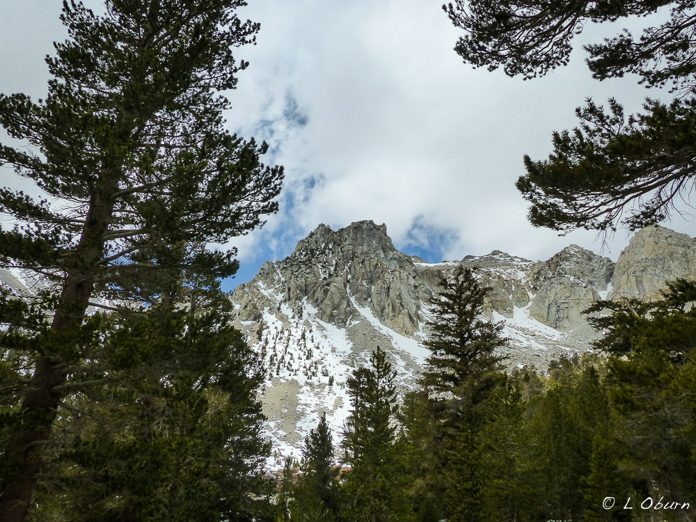
We were planning on two hikes while in the Independence and Big Pine areas, but the forecast wasn’t looking good, with snowstorms predicted in the mountains and rain in the valley.  We decided to camp outside Independence, up at the 6000′ level and get an early start on a hike that began at Onion Valley, the Kearsarge Pass Trail.  We arrived at the trailhead the next morning to a chilly 38º at an elevation of 9200′.  We layered-up and hit the trail.  Unless you have hiked in the mountains, you cannot imagine how breathtaking the alpine lakes can be and there were five that we encountered on our way up to the pass, some still frozen over, awaiting the spring thaw.

Once we cleared the tree line, the howling wind was our lone companion on the barren, windswept trail that switchbacked the remaining 1.5 miles to the pass. Snowflakes swirled around us as we continued our upward trek, but quite frankly, I did not notice their beauty until I stepped onto the pass.  The view down into Kings Canyon National Park, dotted with alpine lakes, was breathtaking.  And the sign indicating that we had arrived at an altitude of 11,760′ put a smile on my face that seemed frozen in place until we began our descent.  Snowflakes danced around us as if to the pulse of Nature’s heartbeat.

Our hike back down seemed colder than earlier in the day, as the winds picked up speed, bringing in a storm that would dump a foot of fresh snow in the mountains that night.  It was a beautiful 10-mile hike, albeit a bit frigid.

We sat out the storm and luckily the days following were warm, so after checking with the rangers and a couple of locals we decided to head out to Big Pine to hike the North Fork Trail.  Originally we thought we would hike to Black Lake to get a view of the Palisade Glacier, the largest in the Sierras and the southernmost in the U.S.  When we came to the fork in the road, we opted for Third Lake, which is fed by the glacier, and was reported to be a milky turquoise color. The hike was the same distance and the lure of several more alpine lakes was too much to pass by.

This hike begins at 7700′ and unlike the many switchbacks on the Kearsarge Pass Trail, it has a grueling long stretch of upward climbing.  You can almost forget about how tiring this first section is by looking at the beauty around you. You catch a glimpse of the Middle Palisade Glacier on this stretch, and some lovely waterfalls.  Once beyond the uphill slog the trail begins to zigzag through a slope of sagebrush, manzanita, and Jeffrey pine, before reaching Second Falls.  And once again you are bewitched by the tantalizing smells and sounds enveloping you.

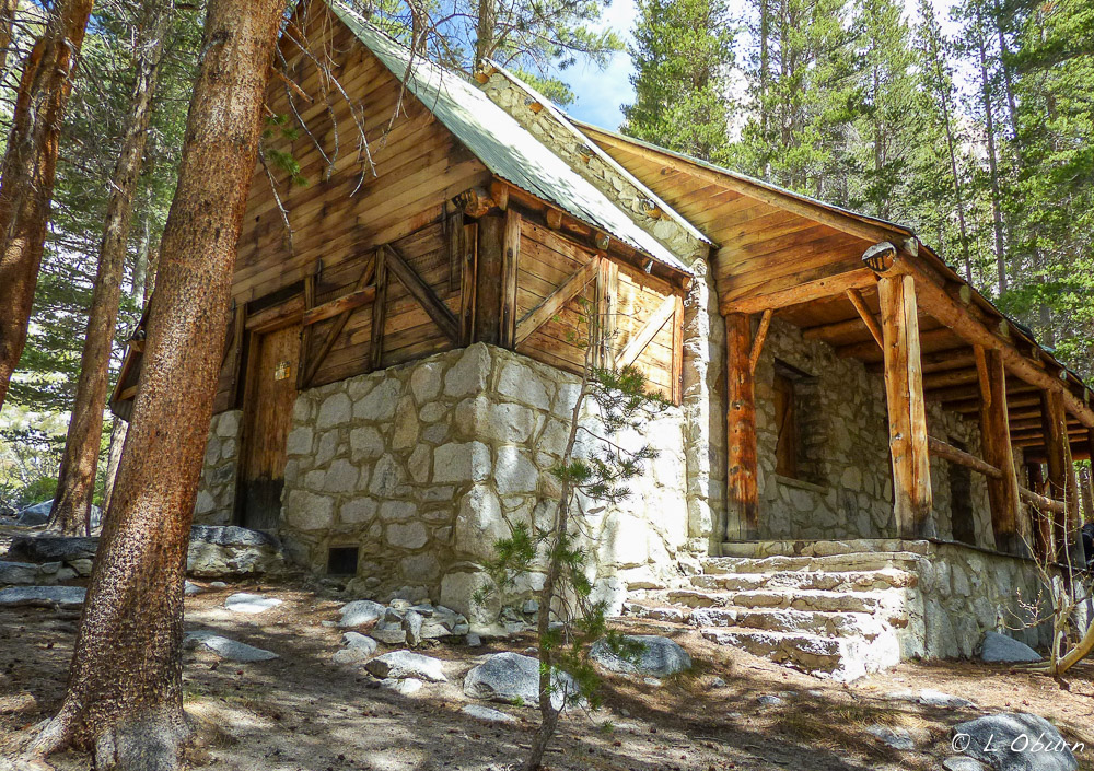
At the 3-mile mark you come upon a cabin built by movie actor Lon Chaney, now used as a wilderness ranger camp, a beautiful setting along a lovely stream.

Lon Chaney cabin
Lon Chaney cabin

Continue upward and you arrive at First Lake, a lovely blue-green oasis sitting in a bowl, then on to Second Lake a short distance later.

First Lake
First Lake
Second Lake
Second Lake
Third Lake with Temple Crag looming overhead

Third Lake, where we planned to stop and have lunch, was a bit of a disappointment, but still a handsome gal with Tempe Crag looming over her.   Given the lack of snowfall these past four years, glacial runoff has not been occurring at the normal rate so her coloring was, shall we say, less than spectacular.  It was still “lunch with a view” as John and Pam would say, and at 10,400′, the air was crisp and the sun was shining.  Once we lightened our load by consuming a few calories we headed back down the trail, making for an exhilarating, but bone-weary 11-mile trek.

There is another storm predicted but we are hopeful to do a few more hikes before we leave the Sierras.  To quote John Muir, there is nothing like hiking in the mountains to “wash your spirit clean”.

Next Stop:  Bishop, CA

A Rare Geologic Site ~ Devil’s Postpile National Monument, CA

“Keep close to Nature’s heart…and break clear away, once in a while, and climb a mountain or spend a week in the woods.  Wash your spirit clean.” ~ John Muir

Horizontal to vertical columns

In early October, while “washing our spirits clean” in the Eastern Sierras we decided a visit to Devil’s Postpile National Monument was in order.  On an overcast, chilly day we headed up the mountain with friends Nina, Paul and their lovely pooch Polly to see this rare geologic site, about 40 minutes outside Mammoth Lakes.

Lovely fall colors against a tumbled stack of basalt

The lighting that day did not allow for this novice photographer to take photos that were very exciting so I quickly set them aside and decided to pass on writing a post.  Today, whether because my spirit longed to walk in the woods again or because I took the time to read a little more about this unusual basalt formation, I decided to dust off the photos and give it another go.

Some say that volcanic lava flow dating back over 100,000 years caused this basalt formation, while other dating methods set the flow as far back as 700,000 years.  Suffice to say that Devil’s Postpile has been here a long time.  The lava flowing to this site became confined within glacial debris and the thickness of the formations was so great, from 400 to 600 feet, that the lava cooled slowly, with the result being long symmetrical columns.  A subsequent glacier polished the surface on the top of the Postpile to a smooth-as-glass finish.

Glacier polished cap
Gray day at the Postpile

Devil’s Postpile columns range from 2 to 3.5 feet in diameter and many reach up to 60 feet in height. Most stand vertically but some are almost horizontal, quite an unusual sight. All the columns would be 6-sided (hexagonal) if the cooling of the lava had occurred perfectly evenly, an impossible feat it would seem.  What makes this basalt formation unique is that 60% of its columns are hexagonal, more than most, designating it one of the world’s finest examples of columnar basalt.  Sadly each year’s freezes and thaws bring down more of the outer columns.

Rainbow Falls
Nina, me, Paul, & Polly at the falls

Talks of building a hydroelectric dam at this very site threatened to collapse this unique spectacle into the San Joaquin River.  In 1911, before this fateful event could take place, an order by President William H. Taft granted Devil’s Postpile the status of National Monument.

If you venture into the Ansel Adams Wilderness near Mammoth Lakes, where the John Muir and Pacific Crest Trails merge together on the monument land, Devil’s Postpile awaits you along a 2-mile hike that eventually leads to Rainbow Falls, a 101-foot drop into the San Joaquin River, named for its many rainbows appearing where the pounding waters flow into the river.  Although no rainbows greeted us on this gray overcast day, Rainbow Falls was an added little bonus at this rare geologic site.

Strong vertical columns falling away

If you liked this blog post, why not scroll up to ‘Follow Us’ and enter your email address?  You just might find something that interests you.

The Mountains are Calling ~ John Muir Wilderness ~ Eastern Sierras, CA

“The mountains are calling and I must go.”  ~  John Muir

Majestic snow-capped peaks

We share this esteemed naturalist’s views, the allure of these mountains is that strong.  It is a spiritual experience, for sure, and the recommended hike passed on to our friend Nina by a forest ranger was to most definitely do Little Lakes Trail.  We were blessed with a rainstorm a few days earlier so we knew without a doubt there would be snow topping the rugged peaks of the John Muir Wilderness where this hike was to take us.

Terry at one of the many striking trailside lakes

Looking at the topographical map at Mosquito Flats, our jumping-off point, we saw evidence of literally hundreds of lakes dotting the mountainsides.  Our hike was to take us by a mere six of these sparkling jewels, ending at Gem Lake, where we lunched lake-side, surrounded by snow-covered granite peaks.  Could life possibly get any better than this?!

The gang lunching at Gem Lake

Considering the hikes we had done at June Lake and many others that were available in this area, Little Lakes was relatively easy, a 7-miler beginning at 10,300 feet and  topping out at just shy of 11,000 feet…piece of cake!  For sightseeing, these are my kind of hikes, not too taxing to leave me huffing and puffing, just a nice, easy hiking pace while enjoying the grandeur all around me, and there was plenty of that!  Sparkling lakes, alpine meadows and many thirteeners surrounded us, Mt. Dade, Mt. Abbot, Mt. Mills, and Bear Creek Spire, to name a few.

The pack, as Nina would say
Paul having a Zen moment

We marveled at the condition of this trail as we wound along meadows and shimmering lakes. Perhaps it is so well-maintained because it is a popular trek. Going early and in the off-season is recommended, as we did, and were rewarded with very few hikers on our way out. This trail is also popular with the fishing and climbing enthusiasts.

Lovely snow-covered hillsides

From our campground at Horton Creek, it is an approximate 45-minute drive on Hwy 395 to get to this lovely trailhead, where the mountains are calling anyone who wants to experience Mother Nature at her finest.

If you liked this blog post, why not scroll up to ‘Follow Us’ and enter your email address?  You just might find something that interests you.


The Tallest of Them All ~ Muir Woods National Monument

Advice from a Tree:  Stand tall and proud/Sink your roots deep into the earth/Be content with your natural beauty/Go out on a limb/Drink plenty of water/Remember your roots/Enjoy the view!  ~  (c) Ilan Shamir  http://www.yourtruenature.com*

The tallest of them all is the Coast Redwood, reaching as high as 380 feet up into the heavens.  We had already seen her bulkier relative, the Giant Sequoia, so we were looking forward to our visit to Muir Woods National Monument.

During peak season it is a must to arrive by 9 am to get a parking space.  We did just that and within an hour the tour buses and cars streamed in.  Our reward for arriving early was no crowds and a lovely, peaceful walk among these giants.  This forest has a mystical, fairy-tale feel, somewhat eerie at times, with tendrils of fog snaking among the trees.  Other times it was so peaceful and quiet (in the Cathedral Grove) that we felt as if we were on hallowed ground – really lovely.

These ancient Coast Redwoods covered many northern California valleys before the 1800’s, then logging took its toll.  In 1905 U.S. Congressman William Kent and wife Elizabeth Thacher Kent purchased land here to protect one of the last stands of these giants.  They donated 295 acres to the federal government to ensure lifetime protection.  In 1908 President Theodore Roosevelt proclaimed Muir Woods a National Monument and at Mr. Kent’s request it was named for renown conservationist John Muir.

Muir Woods can’t boast the tallest redwood on record but does have some reaching upwards of 250 feet, which is amazing given its start comes from a seed no bigger than what you would find in a tomato.  Most redwoods in this stand are 500-800 years old, with the oldest in the forest topping out at 1200 years.  Marine layer fog provides needed moisture for these redwoods, even in the dry season.

Another giant who calls this forest home is the banana slug, the second largest species of slug in the world, growing as long as 9.8 inches.  They move at a speedy 6.5 inches per minute.  Just follow the trail of slime and you are certain to spy one of these unusual mollusks.

Once we had finished wandering the trails and seen the hordes arriving, we decided to hop onto the Dipsea Trail, right off the parking lot.  This is a 9.5 miler round-trip if you go all the way to Stinson Beach but we cut it short at 6.5 miles, stopping at the bluffs overlooking San Francisco Bay, the Golden Gate Bridge and Point Reyes.  It is considered a moderate hike through a beautiful redwood and fir forest.

A trail marker near the top of the bluff peeked our curiosity.

It marks a point on the trail for the annual Dipsea Race, the oldest trail race in America, first run in 1905.  Open to the first 500 entrants, it is run the second Sunday in June and is described as a “grueling and treacherous” 7.4 mile trek from Mill Valley to Stinson Beach.  Sounds suicidal to me!

If you are in these parts and want to see the tallest of them all, Muir Woods National Monument is the perfect place to spend a few hours.  Who knows, you might even get lucky like we did and catch a glimpse of the slippery banana slug.

*NOTE:  To view the poem Advice from a Tree, by Ilan Shamir, in its entirety, see this website or to listen to Mr. Shamir recite his poem to the beat of his cottonwood drum, go here.

If you liked this blog post, why nosubscribe to my blog via feed reader or e-mail?

“The Incomparable Valley” ~ Yosemite National Park (Part 1)

“I have seen persons of emotional temperament stand with tearful eyes, spellbound and dumb with awe, as they got their first view of the Valley from Inspiration Point, overwhelmed in the sudden presence of the unspeakable, stupendous grandeur.”  ~  Galen Clark, guardian of the Yosemite Grant

Stunning vista from Tunnel View (Bridalveil Falls to the right).

Yosemite National Park, referred to as “the incomparable valley”, is probably best known for its grand waterfalls and distinctive granite cliffs.  It offers so much more, as John Muir so beautifully told us in his poems and letters written so long ago.

Reaching across the western slopes of the Sierra Nevada mountain range, Yosemite encompasses 761,268 acres (1200 square miles), roughly the size of Rhode Island.  It has such amazing gifts to offer up, deep valleys, soaring granite cliffs, spectacular waterfalls, clear rushing streams and rivers, stunning meadows, giant sequoia, vast wilderness areas, and biological diversity – the stuff a nature lover’s dreams are made of.  If not for the efforts of renown conservationist and naturalist John Muir and others, 3.5 million annual visitors to this national park today would not be able to enjoy her wonders.

Bridge over Merced River (from Happy Isles Nature Center)

In 1889 John Muir, becoming evermore concerned about the damage being caused by sheep grazing in the High Sierras, launched a campaign with the help of Robert Underwood Johnson, editor of Century Magazine, to persuade Congress to preserve these lands.  Their persistence paid off and on October 1, 1890, Yosemite National Park was established.

Earlier still, in 1855, homesteader Galen Clark wandered upon the Mariposa Grove of Giant Sequoia.  So mesmerized was he by these giants, his personal fight to preserve them from logging soon extended to include Yosemite Valley.  His efforts gained support and the Yosemite Grant was drafted and submitted to Congress.  In 1864 President Abraham Lincoln signed the bill and Yosemite became the first territory ever set aside by Congress for preservation and public use.  Today Galen Clark has a mountain range, the Clark Range, named after him, which can be seen from Glacier Point.

Some of the original inhabitants of the Yosemite Valley were the Miwok Indians. Looking out over the valley, they named it Ahwahnee, “place of the gaping mouth” and later called themselves the Ahwahneechee.  They were followed by Europeans in the mid-1800’s, who quickly set out to displace these native tribes.

Of the 3.5 million who visit here yearly, most do not travel further than the 7 square miles of Yosemite Valley.  If you do nothing but this, there is still much to see.  Some of the more prominent features (but certainly not all-inclusive) that can be seen from Yosemite Valley are:

  • El Capitan (very popular with the rock-climbing set)
El Capitan
  • Half-Dome (can be climbed by permit only from ~ May through October – better views from Glacier Point)
Half Dome
Yosemite Falls (not all is captured in this photo)
Vernal Falls
Nevada Falls (upper right)
Bridalveil Falls
Ahwahnee Hotel
  • Ansel Adams Museum
Except for the Ansel Adams Museum, which we plan to explore later this week, we were able to see all these stunning sights.  Even with our two weeks here, we would never be able to take in all of Yosemite, so we have already decided we will save the eastern part of the park, Tuolumne Meadows, for a later date.
The elegant Ahwahnee Hotel
The Ahwahnee Hotel is a definite must-see, its stunning architecture set against a backdrop of towering granite cliffs.  It was originally built for the wealthy traveling to the park who were looking for more comfort and opulence than that provided by other lodging.  Since 1927, the Ahwahnee Yosemite tradition is the reenactment of Renaissance finery at the famous Bracebridge Dinner.  At this seven-course Yuletide feast you are taken back in time to the 17th century, with jesters, musicians and a court of over 100 players to entertain you for four hours.  I have read that this night of frolicking and festivities will only set you back about $425 (certainly not in our budget).
Terry just down from Vernal Falls

A hike up to Vernal Falls was in our budget (cause it’s free) and provided some quick exercise.  Only about a 1.5 mile hike but with an elevation gain of ~1000 feet and no guard rails to the top, it made for some heart-pounding moments.  It brought back memories of our time touring ruin sites in Mexico, climbing down from the pyramids.  In the past decade more than a dozen people have lost their lives foolishly swimming above the falls.  We watched nervously as many elderly folks with canes tried to make the crowded journey to the top – yikes!

Stay tuned for more photos and stories of this incomparable valley as we hike some of her trails.

“Thousands of tired, nerve-shaken, over-civilized people are beginning to find out that going to the mountains is going home; that wildness is a necessity; and that mountain parks and reservations are useful not only as fountains of timber and irrigating rivers, but as fountains of life.”  ~ John Muir

If you liked this blog post, why nosubscribe to my blog via feed reader or e-mail?