Hiking Extravaganza~ Mt. Rainier National Park

“The clearest way into the Universe is through a forest wilderness.” ~ John Muir

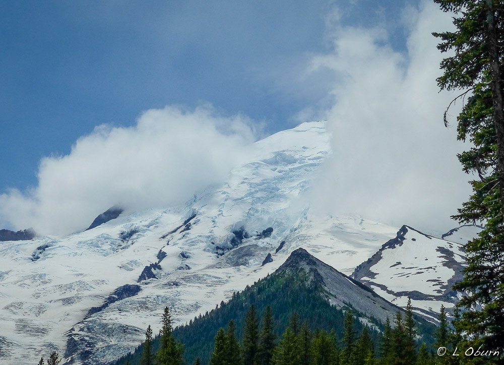
He could be the perfect specimen, this “King of the Cascades”, with those chiseled features, that steely cold gaze, and that red-hot core. Seeing him clearly for the first time, I was smitten! And we were blessed with several clear days where Mt. Rainier’s imposing form rose above the surrounding peaks. Our hikes found me time and again under his spell, as Terry left me trailing far behind, taking photos.

With a total of six days to experience Mt. Rainier National Park, we managed to squeeze in four good hikes and a couple of shorter treks. Hikes were chosen to allow us views of glaciers, some of the park’s most sought after waterfalls, and subalpine meadows bursting with color.  Here are our top four ranked hikes:

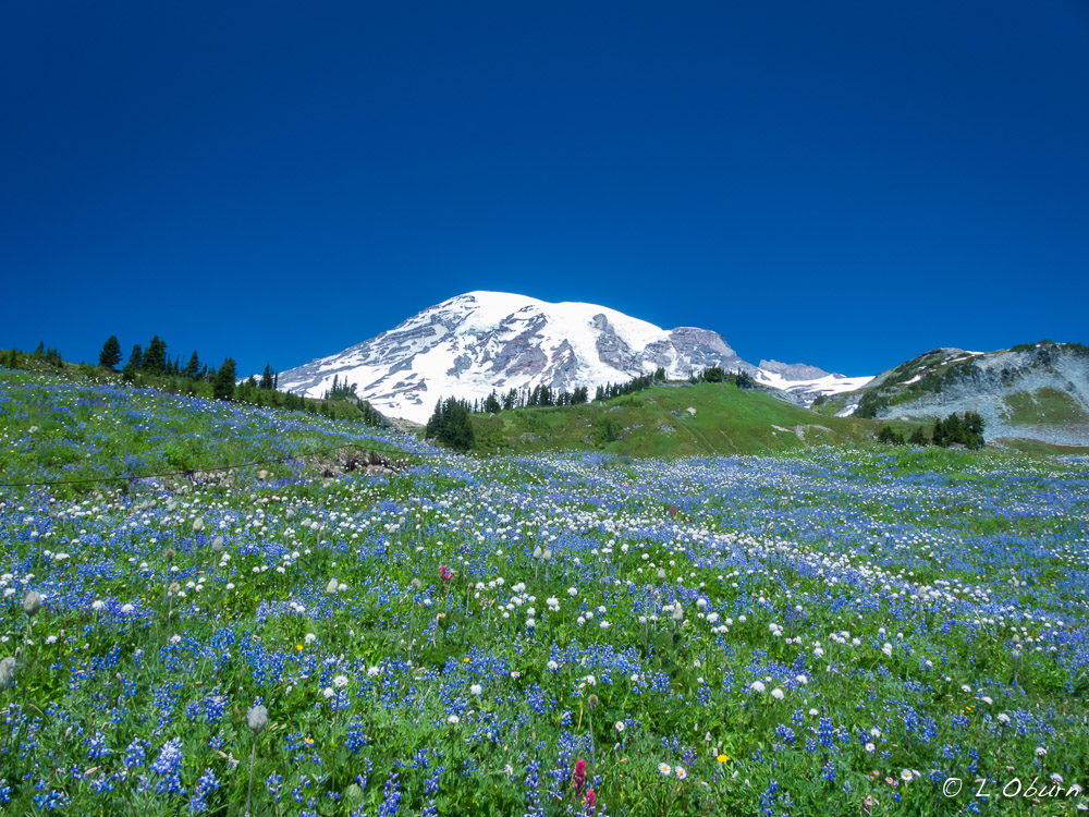
1) Skyline Loop, via the High Skyline Trail

Length: 5.5 miles   Elevation gain: 1700′   Rating:  Strenuous

Prepare to get your heart pounding the moment your feet touch the trail. Even if the elevation didn’t take your breath away, the views certainly would.  Hiking up to Panorama Point, you can hear the mountain groan as you pass by constantly shifting glaciers.  Bring binoculars and you may glimpse climbers at the overnight camp preparing for an early morning summit or a group making their final ascent.  We saw both and silently cheered them on.

And at the end of the trail one final surprise as a beautiful bouquet is strewn beneath the glacier-shrouded throne of Mt. Rainier, like a Monet canvas.

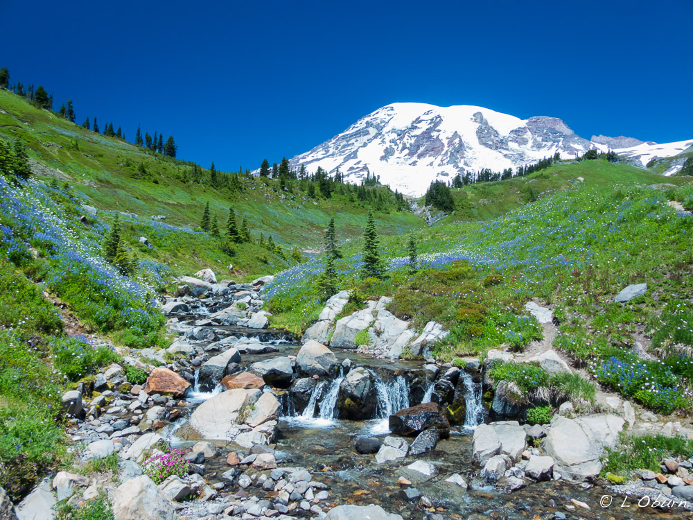
The trailhead begins at Paradise, known for its grand views and wildflower meadows. An average of 680” of snow falls here each winter and it typically lingers until July. The National Park Service says that this is the snowiest place on Earth where snowfall is regularly measured. A world record snowfall of 1122″ was set here during the winter of 1971/72.  This exceptionally warm winter changed the landscape, leaving Paradise with less than 5 feet of snow in March instead of its normal 14 feet.

Paradise Visitor Center is the most popular destination for visitors to Mt. Rainier and the only center open when we visited the park.  The orientation film was great and the exhibits very informative.

On the same grounds is the historic Paradise Inn, built in 1916 and opened for business in 1917. The timber used for the interior décor of the inn and the furniture was cut within the park.

2) Comet Falls/Van Trump Park Trail

Length: 5.6 miles, out and back   Elevation Gain: 2200’   Rating: Strenuous

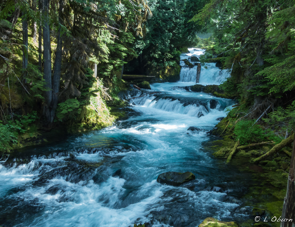
Located near Longmire in the southwestern part of the park, this trail takes you by one of the tallest waterfalls in the park – Comet Falls, plunging 320’ into Van Trump Creek. We sat along the Nisqually River on the return trip, basking in the glow of summer sun and serenaded by rushing water. Boots were off and feet plunged into the icy water…heavenly!

3) Sunrise Rim Trail/Burroughs Mountain

Length: 6.5 miles   Elevation Gain: 2000’   Rating: Strenuous

Located at Sunrise, the highest point accessible by vehicle at 6400’, this was a recommendation by a Park Ranger.  I must admit that sections of this hike left me a bit weak in the knees as the trail became narrow on the side of Burroughs Mountain, steep and sloping precariously towards a 2000’ drop-off down a shale strewn cliff.  It is one of those hikes where it is wise to focus on every step, but it was oh so exhilarating.  Clear views of glaciers and glacial-fed lakes obliterated all other thoughts.  When we were stopped from going any further due to snow and ice, we took a side tour past Frozen Lake and onto Sourdough Ridge for our return back to Sunrise.

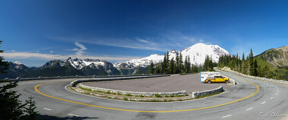
Sunrise Point, on the way to Sunrise, offering 360° views of snow-capped peaks.

4) Glacier Basin Trail

Length: 7.5 miles, hiking part of the unmaintained trail   Elevation Gain: 1700’   Rating: Strenuous

Trailhead located at the White River Campground, south of Sunrise. Beautiful wildflowers waved in the breeze as we hiked the trail, with views of White River, and on this day, shrouded views of Mt. Rainier.

All trails we hiked were rated strenuous as the elevation gain occurred within  a short distance, which made the trek back sweet!

Those that didn’t make the cut:

Silver Falls Trail – From the Ohanapecosh Campground, where we stayed, this 2.5 mile hike takes you to Silver Falls and past a small hot springs area.

Wonderland Trail – 93 mile trail encircling Mt. Rainier.   We hiked 3 miles of it while staying at Cougar Rock Campground to visit a small NPS museum at Longmire.  On our return trip we met a woman who had one mile of the Wonderland Trail left to hike. To say she was on a high is an understatement as she shared her near accomplishment with us, Terry got a high-five from her.

Next up:  The colors and sounds of Mt. Rainier National Park

The Restless Giant ~ Mt Rainier National Park, Part I

“In God’s wildness lies the hope of the world – great fresh unblighted, unredeemed wilderness. The galling harness of civilization drops off, and wounds heal ere we are aware.” ~ John Muir

Subalpine meadows, blanketed with brilliantly colored wildflowers, envelop a glacial  volcano, while time-worn forests grace majestic mountain slopes.  This scene enveloping are senses is better known as Mt. Rainier National Park, our 5th National Park in the U.S., established in 1899.

Covered by 34 square miles of year-round snow and ice, this “king of the Cascades” boasts 25 glaciers on its rugged slopes, which have spawned six major rivers. As much glacial ice covers Mt. Rainier as on all the other Cascade volcanoes combined. It is still considered an active volcano, restless, geologically young, having formed ~ 500,000 years ago. Glaciers and landslides continue to erode Mt. Rainier’s surface, making this imposing mountain look older than it is.

We had read that Mt. Rainier is most often shrouded in a gauzy mist instead of proudly on display. We wondered as we entered the park if we would be fortunate enough to see this formidable giant without swirling clouds obscuring its peak. We were blessed to have several clear days. 🙂

With an average annual snowfall of over 50 feet, snow plays a huge role in Mt. Rainier’s ecology and the entire Cascade Mountain range. It shapes everything we see. Snow conditions determine when wildflowers bloom, when water will be available for wildlife, which glaciers retreat or advance, and which species thrive and which are diminished.

How were these 25 glaciers gracing Mt. Rainier’s slopes formed? For starters, more snow must fall than melts away. As snow piles up, the weight of the snowpack squeezes air out of the lower layers, where the compacted snow crystals start to break down. They recrystallize, forming an entirely different type of snow, called firn. It resembles wet sugar but is much harder and heavier than snow. As surface water trickles down, firn goes through many cycles of melting and refreezing, turning to ice in 3-5 years. Glacial ice scatters incoming light into blue wavelengths, which is why they appear blue to the naked eye. As ice rushes over rock, valley walls, and icefalls, it may break like glass, opening up crevasses up to 100’ deep.

We could hear the groaning and cracking of the glaciers as we hiked some of the ridgeline in the park.

Each year over 10,000 people attempt to scale Mt. Rainer’s highest peak. Nearly half reach the 14,410’ summit. John Muir and nine others climbed to Mt. Rainier’s summit in what became the 5th recorded ascent. His trip to Rainier reinvigorated his efforts to preserve nature as National Parks.

With binoculars in hand on one of our hikes we were able to watch several at the overnight camp prepare for their summit attempt the following morning. We also watched another group making their final ascent. How blessed we were to have a clear day to see this unfold.

Those fortunate souls who do summit find themselves inside a massive crater. They can warm themselves near steam vents if they can stand the “rotten egg” smell of sulfur. There is even a lake underneath all the ice.

I was mesmerized by Mt. Rainier’s raw beauty, its wildness, its power to shun half of those who strive to reach the highest peak.

Next Up: A week of getting deep into the untamed landscape of Mt. Rainer National Park.

Oh Sweet Misery ~ Smith Rock State Park, OR

In Oregon’s high desert, near Terrebonne, striking spires rise up from the Crooked River Canyon. Crafted from molten rock and subsequent flowing water, these basalt tufts have been sculpted into what is now known as Smith Rock State Park. This striking setting draws cyclists, hikers, and photographers, and in the mid-1980’s gained the attention of rock climbers, both local and international. Today more than 1,000 bolted climbing routes dot the vertical basalt walls, challenging beginners and experts alike.

After seeing photos in a brochure, I knew we had to make a slight detour and stop to soak in the views and hopefully take a hike. The 3-mile Misery Ridge Trail, incorporating sections of several other trails, was the hike that would take us up high for views of the surrounding Cascades, the Crooked River, basalt tufts, and Monkey Face Rock. Monkey Face is where we hoped to catch sight of climbers perfecting their sport. Taking the route less traveled, suggested by a Ranger, was to be the easier way down a steep, rocky trail. As I watched others with small children sliding down sections of the trail in the opposite direction, I whispered a silent prayer of thanks to that Ranger.

Starting up The Chute and hiking alongside the Crooked River, both sides of the trail offer enticing views and soon we found “beginner” climbers scaling the chiseled walls. As the hike increased in elevation, Monkey Face Rock absorbed our attention as a group of four climbers clung to the vertical face, the lead climber making his way into the mouth of the big ape. After many photos we continued up Misery Ridge.

Around the backside of Monkey Face we soon realized that two climbers were pushing for the summit, high-fiving one another as they stood at the top looking out over the mountain peaks dotting the horizon. What an exhilarating feeling that must be!

We slowly picked our way down the loose, steep trail, back to The Chute, where are feet once again met level ground.

If you are in the vicinity, a visit to Smith Rock State Park should be on your list, particularly at sunset we are told, as this is the magic hour at this stop.

Gateway to the Cascades ~ Sisters, OR

You know you’re in for a special treat when the view that greets you as you approach town is an impressive skyline of snow-capped peaks.   Welcome to Sisters, where the town’s namesakes, North, South, and Middle Sister Peaks, all towering over 10,000 feet, grace the horizon, literally rising out of her backyard.   Complimenting this imposing panorama are Mt. Jefferson, Mt. Washington, Broken Top, and Three-Fingered Jack, quite a sight to behold.

As Oregon’s highways better developed, Sisters became known as the Gateway to the Cascades. She has retained her Old West flair while having a healthy tourist side, sporting specialty shops, antique stores, galleries, coffee shops, and restaurants.  Our favorite store was Jeffrey Murray Fine Art Photography. His landscape photography drew us in and we learned after visiting with Jeffrey that many of the photos in his gallery were taken during his 5-year sojourn as a full-time RVer. This talented young artist now calls Bend home. You can check out his artistry here.

Since we began our summer travels on May 1st, I have marveled at the places we have been able to squeeze our little Fox into, roads we have traveled, and stops we have made that we would not have attempted with our 5th-wheel. But there are places that even a truck camper should not venture, as we learned during our time in Sisters.

We planned to hike Black Butte and our home was coming with us so decent forest service roads to the trailhead were a must. After only one mile of a 5-mile drive, having been sufficiently bounced around by potholes and constant washboard surface, we reluctantly turned around and moved to Plan B, which became the 82-mile loop drive from Sisters, the McKenzie-Santiam Pass Scenic Byway.  It sounded wonderful, and it was, with a few little twists and turns. 😉

The initial phase of our drive took us to two beautiful “classic” Oregon Cascade waterfalls, via an easy 2.5-mile hike. The McKenzie River plunges over Sahalie Falls in an angry torrent, twists down a boulder-strewn canyon before once again throwing herself off the Koosah Falls cliff. Both falls are breathtaking and have been used in scenes for several movies.

We continued east onto Highway 242 and soon saw signs strongly advising against continuing over McKenzie Pass in vehicles longer than 35 feet.  Terry hesitated, but being well within the limit we chose to carry on, and this is where things got rather interesting.

The road began to narrow, with several sharp turns, but before too long we arrived at our next stop, Proxy Falls. An easy 1.25-mile hike took us to the base of one of the most photographed spots in Oregon. This spectacular waterfall is nestled in a deep, heavily shadowed forest that seemed to evoke ancient myth. Many photos later we continued our slow crawl up the mountain.

The road leading up to McKenzie Pass continued to narrow, with no shoulders and hairpin turns so tight the road seemed to nearly fold back on itself in many places. Vertical rock formations edging the road added to the thrill.  At one point a cyclist came flying down from the opposite direction, barely missing our bumper.  If that wasn’t exciting enough (and it was), moments later a skateboarder, sans helmet, propelled himself down and around a turn, with a car right on his backside. Did I mention there are few guard rails on this road?

You can imagine our relief when we saw the sign for the pass, our final planned stop. On this windswept site sits Dee Wright Observatory, which offers a sweeping panorama of the Cascades and the lava flows that dominate the pass.

The remaining drive back to Sisters was uneventful. Needless to say, our second hiking choice along Highway 242, Black Crater, was crossed off the list as well. Scenic or not, we would not be venturing up that road again.

When we settled into our campsite, Terry pulled out his Mountain Directory book to read their interpretation of McKenzie Pass.  “The “highway” on the west side of this pass is so narrow that in many places a regular-sized vehicle, such as a pickup or van, will be over the center line….A small motorhome might make it over this pass, but there is risk of damage”. This stretch of highway was aptly named Deadhorse Grade.

The hike we finally chose was more sedate than our drive, but no less thrilling, the Tam McArthur Rim trail. This 5-5-mile out-and-back hike, with 2400’ elevation gain, provided lovely views of Three Creek Lake and ended at the base of Broken Top Mountain. The vistas at the top were magnificent.

Our Sisters’ visit, like many, seemed far too short.  We would love to stop back in the fall sometime for the nationally renowned Folk Festival. We hear it is an event not to be missed.

Biking, Brews, Waterfalls and More ~ Bend, OR

I am woefully behind on blog posts and catching up with my blogger friends.  Staying in National Parks often leaves one without cell and internet service but provides such grand vistas and fabulous hikes that I cannot complain.  I will attempt to catch up as time permits.

Leaving Ashland we pointed our rig north and turned our attention to our next destination – Bend.  We were anxious to see this Oregon city but first, a few sights along Hwy 62 were begging to be seen.

Mill Creek Scenic Waterfalls

An easy one mile hike will reward you with views across the river of two lovely waterfalls, Mill Creek Falls cascading 173’ into the Rogue River and multi-stepped Barr Creek Falls, with an impressive 242′ drop.

Avenue of the Boulders

Built from the power of volcanic eruptions and the powerful force of water, the Rogue River drops some 75 feet and makes for a truly spectacular sight. These boulders were thrown all the way from Mt. Mazama when Crater Lake was formed, more than 20 miles away.

Natural Bridge Falls

This is one of nature’s many wonders, where the wild Rogue River (aptly named) disappears into an ancient lava tube and reappears 200’ downstream. You can stand above the inlet and watch this mighty river vanish, taking 30 seconds to travel 200’ to the outlet, where it forcefully bursts through the lava tube.

Our little Fox snuggled into a site among the tall pines

Camping was not to be found near Bend when we arrived as this was the second weekend in June and the Sisters Rodeo was in full-swing. Thankfully LaPine State Park, 20 miles away, had sites available. The South Loop was the place to stay, most recently renovated, and the Fall River Falls 5-mile trail made for a nice hike on a cool morning.

Bend loves bikes and everyone who rides one so we traded in our hiking boots for two wheels and took to the streets.  Downtown offers unique shopping, wonderful coffee shops, and lots of restaurants. Drake Park, one of over 70 verdant public parks, is a great place to stop for a picnic lunch when you have pedaled your way to an appetite. And if the retail bug strikes, a spin out to the Old Mills District along the Deschutes River will provide ample shops where your hard-earned money can be spent. Once home to two large lumber mills, it now houses lots of shops and restaurants, including REI.  Bike the trail there or take to the river and rent a paddleboard or raft for an afternoon of fun.

Another area to bike is the Deschutes River Trail near Sunriver to beautiful Benham Falls, as you wind along open meadows, lava rock formations, and thick-scented forests of pine.

Have you worked up a thirst yet?  Bend has been dubbed the microbrew capital of the West so you should have no problem finding a way to quench those flames.  Bend has so many breweries that some clever marketing master created the Bend Ale Trail, where you can spend your days traveling from one brewery to the next, getting your ticket punched.  We ran into three fellows who had already frequented 6 pubs and were not finished with their day.  None of them appeared to be the designated driver…yikes!

Here are the three brew pubs we sampled in as many days ;):

1)  10 Barrel Brewing Company came recommended by our barista/tour guide at Bluebird Coffee Shop. Twin brothers segued into the craft beer world after a successful downtown Bend restaurant. They may have another success on their hands. We liked the Sinistor Black Ale.


2)  Fairly new to Bend, 3-year old Crux Fermentation Project is what you get when you marry a brew master with a marketing guru. This small-batch brewery has an industrial feel and packs a punch with 15 taps. The winner for us was Nitro Stout.


3)  And for a different twist on breweries, try Rat Hole Brew Pub, an unusual name for this inviting little pub. Les, co-owner with his sister, considers this a “nano-brewery”, very small compared to the others. The brewery itself is housed in his barn, “nothing more than a rat hole”, his sister declared, and the name stuck!  Surprising to us, we liked the Lemon Wheat and Rotation Red.

Visiting Bend was not complete without a visit to the Newberry National Volcanic Monument, where a 9-mile lava flow can be seen. Approximately 7,000 years ago Lava Butte erupted, creating this surreal landscape. Lava Butte is just one of over 400 cinder cones found at Newberry.

Newberry Volcano, a shield volcano, is one of the largest volcanos in the lower 40 states. It has created massive lava flows covering 1200 square miles in its 400,000-year history. In the 1960’s astronauts came to train on the Newberry lava for their mission to the moon.

There is so much more to see in this area than our time allowed, nothing that a return visit won’t cure.  We learned that Bend has also been named “one of America’s most romantic cities”.  Perhaps love will be in the air for our next visit. 😉

Next Up: Sisters, a town with an Old West flair