Tidepools, Waterfalls, Moody Beaches ~ Olympic National Park

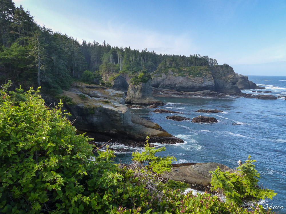
Olympic National Park, encompassing 1441 square miles of the Olympic Peninsula, is known as “a gift from the sea” by its native residents.  It has three distinctly different ecosystems – jagged, glacier-capped mountains, more than 70 miles of rugged Pacific coastline, and majestic stands of old-growth trees and temperate rain forest.

Although we had carved out a month to visit the Olympic Peninsula, time became elusive.  The Pacific Northwest weather can be a fickle gal so staying put awaiting a clear day can quickly find you rushing to catch up to your fleeting schedule.

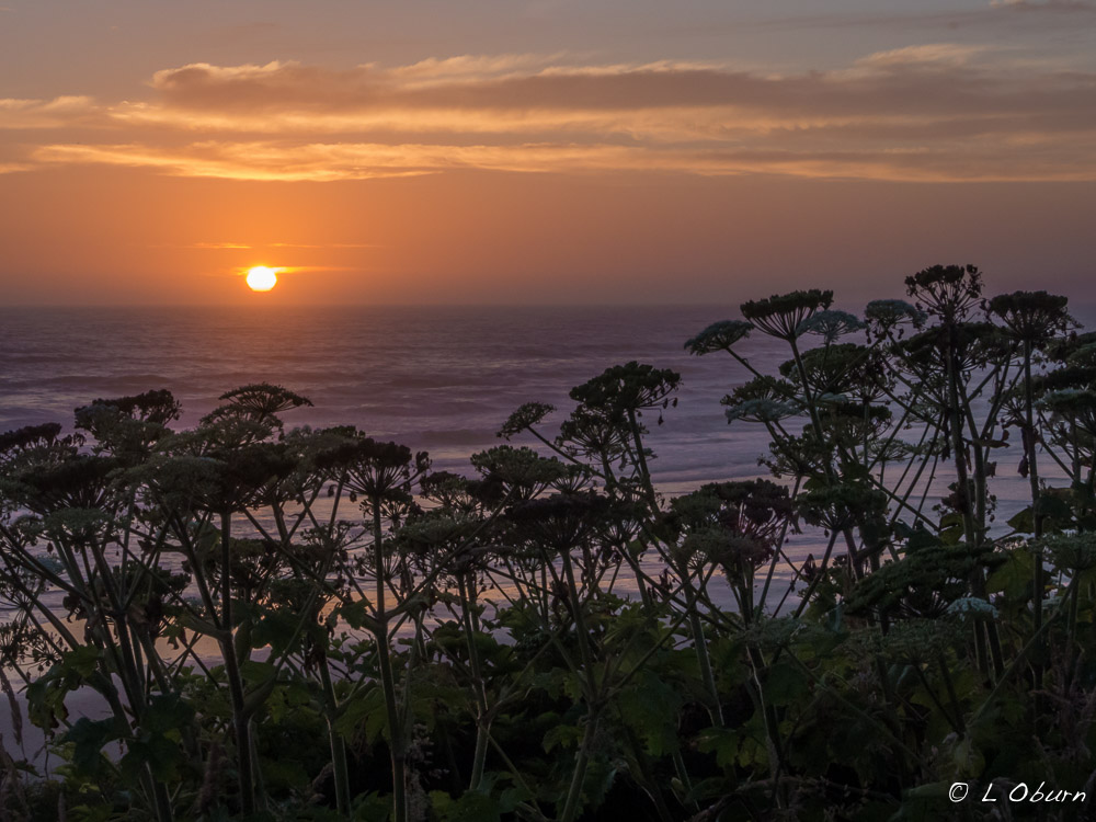
Leaving South Beach on a clear, cloudless day, we hoped for a clear view of one of the more scenic beaches, Ruby Beach. Beaches on this craggy coastline have as many moods as do we, sometimes bright and clear but other times dark and brooding, laden with fog.  Our initial visit to Ruby Beach was the latter, but I so love all the many moods of these coastal beaches.  Misty, foggy days, a freshness to the wind as if it had been infused with ozone…oh my!  The light mist seemed to heighten smells, enhancing the richness of the sea air.

Mora Campground, just north of La Push was our next stop in Olympic NP.  Like many other national park campgrounds, unless you are packing a tent or pulling a small RV, you may want to seek camping outside the park.  We had scoped out this campground to visit Rialto Beach and hike to the sea-carved arch, Hole-in-the Wall, at low tide.  Two trips to Rialto were needed as our first attempt brought us to an invisible beach of dense fog.  Later that evening she was still a brooding beach but with enough visibility to make our way up to Hole-in-the Wall.  Low tide revealed little interesting sea life but made for a nice three-mile out-and-back walk near sunset.

Bleached driftwood strewn along the beach reminded me of prehistoric bones picked clean by the sea, enhancing the eerie feeling.

Then it was on to the mystical land of vampires and werewolves, thanks to Stephanie Meyer’s successful “Twilight” series.

This sign did the trick. No vampire or werewolf sightings in the area.

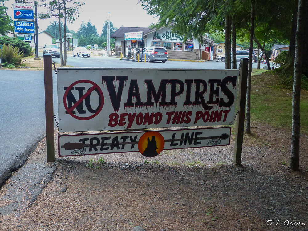
Many travel to the north Olympic Peninsula to retrace the footsteps of some of their favorite “Twilight” characters, the epicenter being Forks and La Push.   Although none of the movies were filmed in either of these small towns, tourists still flock to the area to visit sites such as the Forks High School, where Bella and Edward met, and La Push, where Bella visited her werewolf friend, Jacob.  Click here to see where the movies were filmed.

Forks is one of the region’s logging capitals and Washington’s wettest town, charting 100+ inches of rain per year.

We had read that Second and Third Beaches were both great for tide pooling. As our time was short we chose one, Second Beach, and hit the jackpot at low tide. The area was bursting with ochre sea stars, green sea anemones, and aggregating anemones.

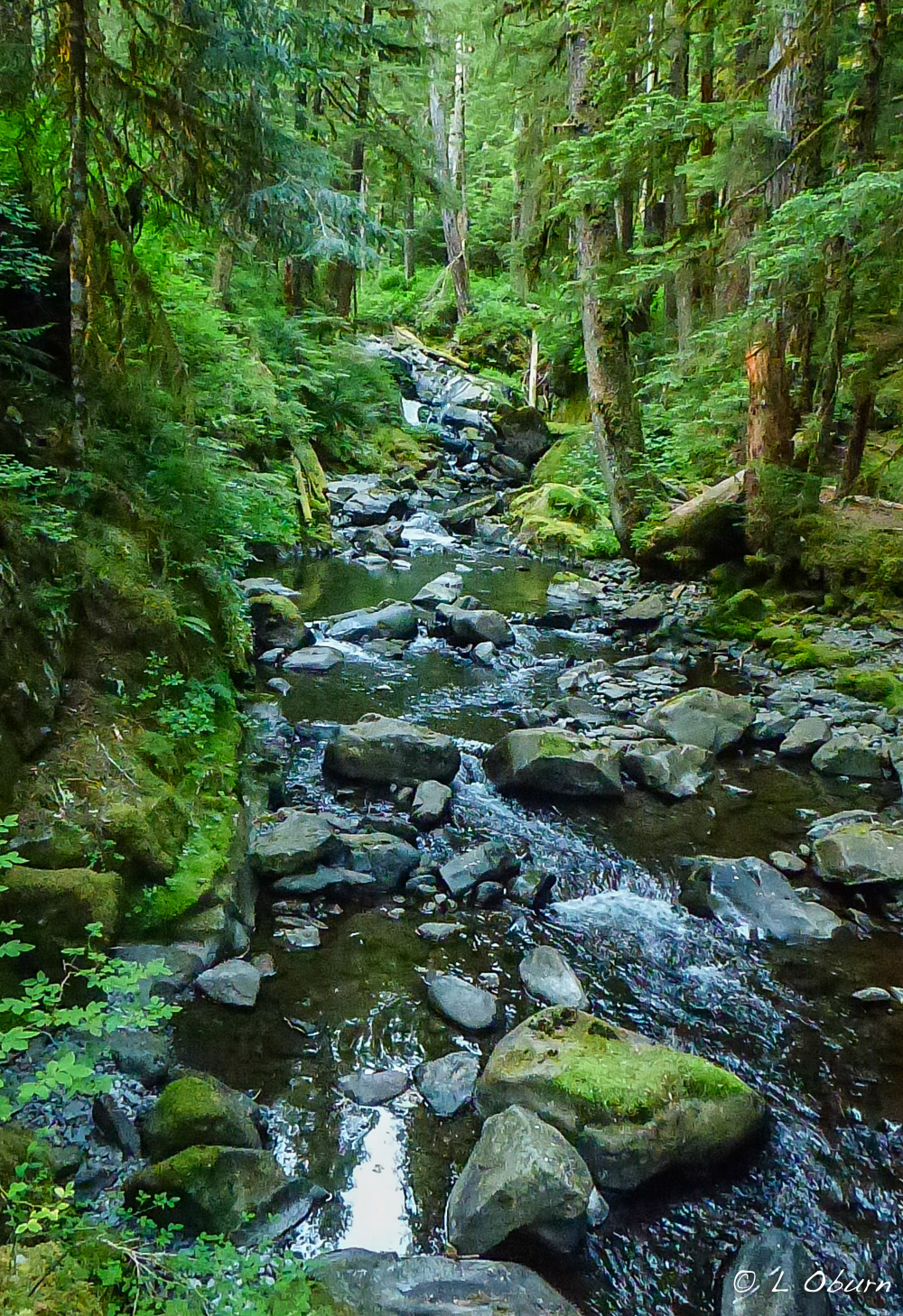
Stepping away from the coast for a few days, we moved east to Sol Duc Hot Springs Campground, where we hiked the six-mile Sol Duc Falls/Lovers’ Lane Loop. The Sol Duc Falls is a segmented waterfall, quite the stunner, and the old-growth forest we hiked was lush.  The Sol Duc River that meanders through the forest serves as a key waterway for coho and chinook salmon.  It is one of the few places where salmon run in every season.  This area is also home to the Sol Duc Hot Springs, which has an interesting Native American legend tied to it.  You can read all about it here.

This forest, like others, had a smell reminiscent of cotton candy, transporting me back to my childhood. Images of sticky smiles, colored pink and blue, danced before me as I dodged tree roots in the path, while the smell of spun sugar teased my memory.

Smoke-filled Lake Crescent

After one night in Sol Duc Valley we were on the move again, stopping at Fairholme Campground on Lake Crescent.  This lovely lake is known for its brilliant teal-colored waters and extraordinary clarity, due to a lack of nitrogen in the lake that inhibits algae growth.  Instruments have recorded depths in excess of 1000′, although many records reflect a maximum depth of 625′ in this glacially carved lake.

Kayaking was on the agenda but two fires nearby caused smoke to settle over the lake.  Biking the Spruce Railroad Trail made the list instead for a nice 15-mile bike ride.

We then took to the forest and hiked 2 miles to little Marymere Falls, where a side trail ended at Historic Lake Crescent Lodge.  We both agreed this would be a great place to come back and stay.

This rounded out week two of our enchanting time in Olympic National Park.  It was time to  get back to civilization.

Land of Diversity ~ Olympic Peninsula, Washington

Snow-capped mountains, temperate rain forests, fog-shrouded beaches, and wild coastline – this is the Olympic Peninsula.

Over 3600 square miles of land in western Washington, largely unmapped until 1898, encompass the Olympic Peninsula.  Although not an island, it is technically bordered by water on all sides: to the north, the Strait of Juan de Fuca, or the Salish Sea as it is known by the locals, separates the US from Canada; on the east the Puget Sound extends nearly 100 miles; the vast Pacific Ocean crashes into the rugged west coastline, creating dramatic tree-topped sea stacks; and the only fresh water barrier is the Chehalis River on the south.

The Olympic mountain range dominates the center of the peninsula, the second largest range in Washington behind the Cascades.  This is not a tall mountain range, Mt. Olympus being the tallest at just under 8,000’, but can still boast about 266 glaciers crowning their peaks.  The most prominent of these glaciers, eight of them, cover 10 square miles of slopes on Mt. Olympus.

The Olympic peninsula contains many salmon-bearing rivers, several natural lakes, many state parks, and one national park, Olympic, where we focused our explorations.

The Wild Olympics Campaign is underway to protect additional wilderness areas within the peninsula, protect salmon under the Wild and Scenic River Act, and provide Olympic National Park a way to acquire additional land near the park from willing sellers.

Olympic National Park protects one of the largest stretches of wilderness coastline in the lower 48 states, over 70 miles.  Rough seas have resulted in treacherous shoreline, no doubt helping to preserve this remote and pristine coast.  Eight American Indian tribes continue to call small fishing villages along this coastline home, working to keep their ancestral traditions alive.  Today the coast appears much as it did when their ancestors paddled cedar canoes past rocky coves and beaches.

Even today severe weather and currents have doomed many a ship that has challenged this remorseless shoreline.  Lives have been lost and thousands of gallons of spilled oil have devastated immaculate beaches, killing sea birds and disrupting delicate ecosystems.

We planned a month here to soak in the beauty of the national park and surrounded headland, absorbing as much history of the area as possible, with the added bonus of meeting several sets of friends along the way.

Our first week on the coast proved to be a laid back time.  With a holiday and the potential for crazy busy campgrounds, we booked a reservation at Kalaloch Campground in Olympic National Park, ensuring we had a place to call home for the 4th holiday.  Although our Arctic Fox is small in stature, our campsite was an unlevel tight fit.  Adjacent sites were close together as well, but we were happy to be here so quickly set up and headed to the beach to walk in the fog and shake off some road dust.

Terry being enveloped by the fog

When we returned to camp our neighbor had his rap music cranked up and felt the need to berate his wife and children in front of the rest of the campground.  Surprisingly the kids were much better behaved.  As this continued throughout the day we made it our mission the next morning to find a suitable campground for the holiday weekend. South Beach was our answer.  Though nothing more than a gravel parking lot, we had a beachfront site where we enjoyed brisk ocean breezes, long walks on fog-shrouded beaches, lovely sunsets, and easy access to day trips.

We explored the Lake Quinault area, where the 1926 historic Lake Quinault Lodge stands.  This area is often called the Valley of the Rain Forest Giants, being home to some of the largest and most impressive trees, such as the largest Sitka spruce tree in the world (how do they know this?).

We had read much about the Hoh River Rain Forest, which is purported to be one of the best examples of a temperate rain forest in the world, so this became another of our scheduled day treks.  We hiked the Hoh River Trail, winding through a forest of spike moss-laden trees.  It doesn’t harm the trees but can weigh as much as four times that of the trees own foliage.  We both agreed that this rain forest looked very dry, likely the result of this year’s drought.

Beyond this we were content to walk miles of driftwood-strewn beaches for the week and our fireworks were compliments of Mother Nature. 🙂

This was our fireworks display on the 4th, at South Beach.

Next Up:  Moody beaches and tide pools

Wildflowers, Waterfalls, and a Little Wildlife ~ Mt. Rainier National Park, Part III

“…the most luxuriant and the most extravagantly beautiful of all the alpine gardens I ever beheld in all my mountaintop wanderings.” ~ John Muir 1889   

We had seen some lovely wildflowers in our travels this summer but nothing prepared me for Mt. Rainier National Park’s subalpine meadows bursting with color.   Trails were lined with multiple varieties of flowers, as if a master gardener had lovingly selected and planted each. Every path we stepped onto seemed to be more colorful than the last, a grand mosaic of diversity.

Pungent smell of living trees and soil surrounded us. Air so pure and sweet that our lungs eagerly expanded to drink in the delicious nectar.

The glacier lily, aka yellow avalanche lily, may be one of the most resilient of wildflowers growing on the slopes of Mt. Rainier.  It can generate its own heat, melt a hole in the snow, and poke through the snowmelt, giving it a distinct advantage over the other meadow plants that must await the melting snow.  In all our wanderings I was not able to find this beautiful little flower.

Snow dominates much of the landscape here, blanketing the earth for several months at a time.  Many of the evergreen trees have a contorted shape, twisted by ice and wind.  These subalpine trees grow very slowly and are called krummholz, German name for “twisted wood”.

Paths were spongy, carpeted by countless layers of fir needles and bark. Lichen and miniscule mosses attached themselves to everything that stood still – fallen logs, stately Douglas fir, Western hemlock, and river-polished boulders. Tiny fir trees begin life here in this fertile soil, fallen trees acting as nurseries, adding to the varied shades of green seen along the trails. Heavily scented forests intoxicate, while the roaring rivers busily rush to their terminus, simple, magical experiences found in nature.

The sound of running water can be heard throughout the park, sometimes soothing, sometimes almost deafening, always rushing to get to an unknown destination.  Waterfalls are plentiful due to snow and glacial runoff, and misty spray dances as sunlight caresses water droplets, sparkling like jewels, no two waterfalls alike, each uniquely their own.

Other than the sounds of whistling marmots heard almost non-stop, this is the only little bit of wildlife that we spotted, and he was certainly a cute little guy.

Mt. Rainier speaks to the vastness of a world intense with growth and birth. It was the perfect time to experience this wonder, the season of life between the sleeping winter and autumn’s move towards dormancy.

Next Up:  The Wild, Rugged Olympic Peninsula

Hiking Extravaganza~ Mt. Rainier National Park

“The clearest way into the Universe is through a forest wilderness.” ~ John Muir

He could be the perfect specimen, this “King of the Cascades”, with those chiseled features, that steely cold gaze, and that red-hot core. Seeing him clearly for the first time, I was smitten! And we were blessed with several clear days where Mt. Rainier’s imposing form rose above the surrounding peaks. Our hikes found me time and again under his spell, as Terry left me trailing far behind, taking photos.

With a total of six days to experience Mt. Rainier National Park, we managed to squeeze in four good hikes and a couple of shorter treks. Hikes were chosen to allow us views of glaciers, some of the park’s most sought after waterfalls, and subalpine meadows bursting with color.  Here are our top four ranked hikes:

1) Skyline Loop, via the High Skyline Trail

Length: 5.5 miles   Elevation gain: 1700′   Rating:  Strenuous

Prepare to get your heart pounding the moment your feet touch the trail. Even if the elevation didn’t take your breath away, the views certainly would.  Hiking up to Panorama Point, you can hear the mountain groan as you pass by constantly shifting glaciers.  Bring binoculars and you may glimpse climbers at the overnight camp preparing for an early morning summit or a group making their final ascent.  We saw both and silently cheered them on.

And at the end of the trail one final surprise as a beautiful bouquet is strewn beneath the glacier-shrouded throne of Mt. Rainier, like a Monet canvas.

The trailhead begins at Paradise, known for its grand views and wildflower meadows. An average of 680” of snow falls here each winter and it typically lingers until July. The National Park Service says that this is the snowiest place on Earth where snowfall is regularly measured. A world record snowfall of 1122″ was set here during the winter of 1971/72.  This exceptionally warm winter changed the landscape, leaving Paradise with less than 5 feet of snow in March instead of its normal 14 feet.

Paradise Visitor Center is the most popular destination for visitors to Mt. Rainier and the only center open when we visited the park.  The orientation film was great and the exhibits very informative.

On the same grounds is the historic Paradise Inn, built in 1916 and opened for business in 1917. The timber used for the interior décor of the inn and the furniture was cut within the park.

2) Comet Falls/Van Trump Park Trail

Length: 5.6 miles, out and back   Elevation Gain: 2200’   Rating: Strenuous

Located near Longmire in the southwestern part of the park, this trail takes you by one of the tallest waterfalls in the park – Comet Falls, plunging 320’ into Van Trump Creek. We sat along the Nisqually River on the return trip, basking in the glow of summer sun and serenaded by rushing water. Boots were off and feet plunged into the icy water…heavenly!

3) Sunrise Rim Trail/Burroughs Mountain

Length: 6.5 miles   Elevation Gain: 2000’   Rating: Strenuous

Located at Sunrise, the highest point accessible by vehicle at 6400’, this was a recommendation by a Park Ranger.  I must admit that sections of this hike left me a bit weak in the knees as the trail became narrow on the side of Burroughs Mountain, steep and sloping precariously towards a 2000’ drop-off down a shale strewn cliff.  It is one of those hikes where it is wise to focus on every step, but it was oh so exhilarating.  Clear views of glaciers and glacial-fed lakes obliterated all other thoughts.  When we were stopped from going any further due to snow and ice, we took a side tour past Frozen Lake and onto Sourdough Ridge for our return back to Sunrise.

Sunrise Point, on the way to Sunrise, offering 360° views of snow-capped peaks.

4) Glacier Basin Trail

Length: 7.5 miles, hiking part of the unmaintained trail   Elevation Gain: 1700’   Rating: Strenuous

Trailhead located at the White River Campground, south of Sunrise. Beautiful wildflowers waved in the breeze as we hiked the trail, with views of White River, and on this day, shrouded views of Mt. Rainier.

All trails we hiked were rated strenuous as the elevation gain occurred within  a short distance, which made the trek back sweet!

Those that didn’t make the cut:

Silver Falls Trail – From the Ohanapecosh Campground, where we stayed, this 2.5 mile hike takes you to Silver Falls and past a small hot springs area.

Wonderland Trail – 93 mile trail encircling Mt. Rainier.   We hiked 3 miles of it while staying at Cougar Rock Campground to visit a small NPS museum at Longmire.  On our return trip we met a woman who had one mile of the Wonderland Trail left to hike. To say she was on a high is an understatement as she shared her near accomplishment with us, Terry got a high-five from her.

Next up:  The colors and sounds of Mt. Rainier National Park

The Restless Giant ~ Mt Rainier National Park, Part I

“In God’s wildness lies the hope of the world – great fresh unblighted, unredeemed wilderness. The galling harness of civilization drops off, and wounds heal ere we are aware.” ~ John Muir

Subalpine meadows, blanketed with brilliantly colored wildflowers, envelop a glacial  volcano, while time-worn forests grace majestic mountain slopes.  This scene enveloping are senses is better known as Mt. Rainier National Park, our 5th National Park in the U.S., established in 1899.

Covered by 34 square miles of year-round snow and ice, this “king of the Cascades” boasts 25 glaciers on its rugged slopes, which have spawned six major rivers. As much glacial ice covers Mt. Rainier as on all the other Cascade volcanoes combined. It is still considered an active volcano, restless, geologically young, having formed ~ 500,000 years ago. Glaciers and landslides continue to erode Mt. Rainier’s surface, making this imposing mountain look older than it is.

We had read that Mt. Rainier is most often shrouded in a gauzy mist instead of proudly on display. We wondered as we entered the park if we would be fortunate enough to see this formidable giant without swirling clouds obscuring its peak. We were blessed to have several clear days. 🙂

With an average annual snowfall of over 50 feet, snow plays a huge role in Mt. Rainier’s ecology and the entire Cascade Mountain range. It shapes everything we see. Snow conditions determine when wildflowers bloom, when water will be available for wildlife, which glaciers retreat or advance, and which species thrive and which are diminished.

How were these 25 glaciers gracing Mt. Rainier’s slopes formed? For starters, more snow must fall than melts away. As snow piles up, the weight of the snowpack squeezes air out of the lower layers, where the compacted snow crystals start to break down. They recrystallize, forming an entirely different type of snow, called firn. It resembles wet sugar but is much harder and heavier than snow. As surface water trickles down, firn goes through many cycles of melting and refreezing, turning to ice in 3-5 years. Glacial ice scatters incoming light into blue wavelengths, which is why they appear blue to the naked eye. As ice rushes over rock, valley walls, and icefalls, it may break like glass, opening up crevasses up to 100’ deep.

We could hear the groaning and cracking of the glaciers as we hiked some of the ridgeline in the park.

Each year over 10,000 people attempt to scale Mt. Rainer’s highest peak. Nearly half reach the 14,410’ summit. John Muir and nine others climbed to Mt. Rainier’s summit in what became the 5th recorded ascent. His trip to Rainier reinvigorated his efforts to preserve nature as National Parks.

With binoculars in hand on one of our hikes we were able to watch several at the overnight camp prepare for their summit attempt the following morning. We also watched another group making their final ascent. How blessed we were to have a clear day to see this unfold.

Those fortunate souls who do summit find themselves inside a massive crater. They can warm themselves near steam vents if they can stand the “rotten egg” smell of sulfur. There is even a lake underneath all the ice.

I was mesmerized by Mt. Rainier’s raw beauty, its wildness, its power to shun half of those who strive to reach the highest peak.

Next Up: A week of getting deep into the untamed landscape of Mt. Rainer National Park.